IMAGES TAKEN NEAR TO
Manor Farm Road, WEMBLEY, HA0 1XB
Introduction
This page details the photographs taken nearby to Manor Farm Road, HA0 1XB by members of the Geograph project.
The Geograph project started in 2005 with the aim of publishing, organising and preserving representative images for every square kilometre of Great Britain, Ireland and the Isle of Man.

There are currently over 7.5m images from over14,400 individuals and you can help contribute to the project by visiting https://www.geograph.org.uk
Image Map
Images are licensed for reuse under creativecommons.org/licenses/by-sa/2.0
Notes
- Clicking on the map will re-center to the selected point.
- The higher the marker number, the further away the image location is from the centre of the postcode.
Image Listing (119 Images Found)
Images are licensed for reuse under creativecommons.org/licenses/by-sa/2.0
Image
Details
Distance
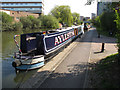
2
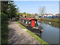
Eefer - narrow boat on Paddington Arm, Grand Union Canal
Image: © David Hawgood
Taken: 20 Apr 2015
0.09 miles
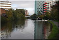
4
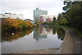
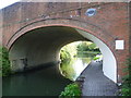
The Paddington Arm of the Grand Union Canal at Alperton
The Paddington Arm of the then Grand Junction Canal was opened in 1801 from Bull's Bridge near Southall to Paddington Basin. The canals were initially a success, particularly for transporting coal, building materials and other bulky loads, but the rise of the railways not long after the canals were built substantially reduced their importance. Now they are primarily a leisure facility. The Paddington Arm was one of the last to see the old-fashioned style of regular commercial traffic of paired narrow boats carrying the traditional materials such as coal, oils, and tar. The Paddington Arm now sees regular commercial traffic, usually in the form of aggregates.
The towpath is followed by the Grand Union Canal Walk. Here it has just passed under Manor Farm Road at Alperton as seen at http://www.geograph.org.uk/photo/4198520
Image: © Marathon
Taken: 8 Oct 2014
0.10 miles
5
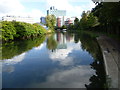
Aylestone - narrow boat on Paddington Arm, Grand Union Canal
Image: © David Hawgood
Taken: 20 Apr 2015
0.10 miles
6
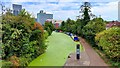
Duckweed on the canal
Looking east from Piggery Bridge, we see the canal blanketed in duckweed.
Image: © Mark Percy
Taken: 2 Sep 2022
0.10 miles
7
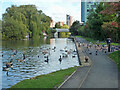
Waterfowl, Grand Union Canal, Paddington Arm
And pigeons.
Image: © Robin Webster
Taken: 6 Oct 2012
0.10 miles
9
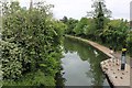
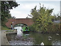
The canal towpath at Manor Farm Road bridge
The Paddington Arm of the then Grand Junction Canal was opened in 1801 from Bull's Bridge near Southall to Paddington Basin. The canals were initially a success, particularly for transporting coal, building materials and other bulky loads, but the rise of the railways not long after the canals were built substantially reduced their importance. Now they are primarily a leisure facility. The Paddington Arm was one of the last to see the old-fashioned style of regular commercial traffic of paired narrow boats carrying the traditional materials such as coal, oils, and tar. The Paddington Arm now sees regular commercial traffic, usually in the form of aggregates.
The towpath is followed by the Grand Union Canal Walk. Here it passes under Manor Farm Road at Alperton.
Image: © Marathon
Taken: 8 Oct 2014
0.11 miles
10
Barge passing under Manor Farm Road bridge on the Paddington Branch of the Grand Union Canal
Image: © Rod Allday
Taken: 16 Oct 2015
0.11 miles