IMAGES TAKEN NEAR TO
Row Lane, GUILDFORD, GU5 9EL
Introduction
This page details the photographs taken nearby to Row Lane, GU5 9EL by members of the Geograph project.
The Geograph project started in 2005 with the aim of publishing, organising and preserving representative images for every square kilometre of Great Britain, Ireland and the Isle of Man.

There are currently over 7.5m images from over14,400 individuals and you can help contribute to the project by visiting https://www.geograph.org.uk
Image Map
Images are licensed for reuse under creativecommons.org/licenses/by-sa/2.0
Notes
- Clicking on the map will re-center to the selected point.
- The higher the marker number, the further away the image location is from the centre of the postcode.
Image Listing (25 Images Found)
Images are licensed for reuse under creativecommons.org/licenses/by-sa/2.0
Image
Details
Distance
1
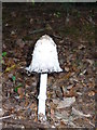
Fruit of the Earth, Winterfold
Mushroom, about six inches tall, growing through leaf litter outside Winterfold Cottage. Perhaps a shaggy inkcap?
Image: © Colin Smith
Taken: 28 Sep 2008
0.04 miles
2
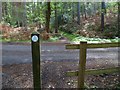
Bridleway on the eastern side of Winterfold Wood
This appears to have a blue bridleway marker. I am not quite sure if I have placed the picture rightly. Some maps show a bridleway and others a footpath.
Image: © Shazz
Taken: 19 Sep 2011
0.06 miles
3
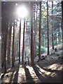
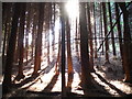
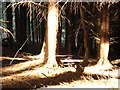
Winterfold Forest
Looking uphill, through the pine woods. The dark trees permit little light to reach the forest floor here at the bottom of a narrow dry valley.
Image: © Colin Smith
Taken: 28 Sep 2008
0.06 miles
4
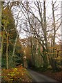
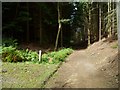
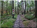
Row Lane, heading south through Winterfold Wood
A narrow, sunken lane - typical of many in this hilly part of Surrey. On the west side, the beeches on the bank 'lean into' the lane. Much of Winterfold Wood is now conifer plantation, and I saw plenty of evidence of recent felling.
You are quite high up here - at about 150m - and further south the map shows a spot-height in Winterfold Wood of 207m.
Photo taken in mid-November.
Image: © Stefan Czapski
Taken: 20 Nov 2014
0.06 miles
5
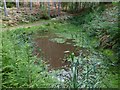
Pond on the eastern side of Winterfold Wood
This might be the pond named as Lamb's Well. On the far side is the bridleway and the fencing at a track can be seen a little way on.
Image: © Shazz
Taken: 19 Sep 2011
0.08 miles
6
Bridleway on the eastern side of Winterfold Wood crosses track
Image: © Shazz
Taken: 19 Sep 2011
0.10 miles
7
The Depths of Winterfold Forest
Light streaming down the hillside, through the densely packed pine trees, to the dry valley bottom. The hillside has a sandy surface.
Image: © Colin Smith
Taken: 28 Sep 2008
0.11 miles
8
Forest Floor, Winterfold
A bright patch in an otherwise dark and gloomy patch of dense pine woodland. Being at the foot of a narrow and steep valley also hinders sunlight reaching here.
Image: © Colin Smith
Taken: 28 Sep 2008
0.11 miles
9
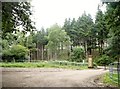
Forestry notices in Winterfold Wood
As is frequently the case the notices were misleading and there was no tree felling in progress.
Image: © Shazz
Taken: 19 Sep 2011
0.13 miles