IMAGES TAKEN NEAR TO
Bowers Lane, GUILDFORD, GU4 7ND
Introduction
This page details the photographs taken nearby to Bowers Lane, GU4 7ND by members of the Geograph project.
The Geograph project started in 2005 with the aim of publishing, organising and preserving representative images for every square kilometre of Great Britain, Ireland and the Isle of Man.

There are currently over 7.5m images from over14,400 individuals and you can help contribute to the project by visiting https://www.geograph.org.uk
Image Map
Images are licensed for reuse under creativecommons.org/licenses/by-sa/2.0
Notes
- Clicking on the map will re-center to the selected point.
- The higher the marker number, the further away the image location is from the centre of the postcode.
Image Listing (122 Images Found)
Images are licensed for reuse under creativecommons.org/licenses/by-sa/2.0
Image
Details
Distance
1
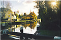
Bowers Lock, Burpham
On the Wey Navigation in Guildford, now used by narrow boats and small cruisers. On the left is the old Bowers Mill, now residential.
Image: © Colin Smith
Taken: Unknown
0.01 miles
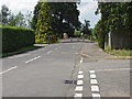
2
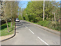
Bower's Lane
A view of Bower's Lane looking towards the junction with Clay Lane.
Image: © Alan Hunt
Taken: 3 May 2013
0.02 miles
3
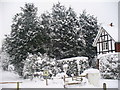
Burpham - the End of Bowers Lane
A rare snowy day on the Wey Navigation in Burpham, Guildford. The snow lies about 1 foot deep and to the left is the towpath.
Image: © Colin Smith
Taken: 2 Feb 2009
0.02 miles
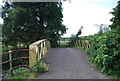
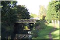
5
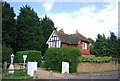
Bower's Lane, Jacob's Well
The short residential road off Clay Lane with the iron bridge over the Wey Navigation.
Image: © Alan Hunt
Taken: 12 Jul 2014
0.03 miles
6
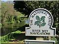
Guildford - River Wey Navigations
National Trust sign beside the Wey near Bowers Lock.
www.weyriver.co.uk
Image: © Colin Smith
Taken: 21 Apr 2020
0.03 miles
7
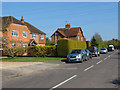
Bower's Lane
The short residential road off Clay lane near the River Wey Navigation.
Image: © Alan Hunt
Taken: 3 May 2013
0.03 miles
9
Bridges at Clay Lane
Clay Lane, connecting Burpham with Jacobs Well and, ultimately, Woking, used to cross the Wey Navigation on the slender bridge in the foreground. It was not until the late 1970s that the road was diverted as part of the A3 bypass scheme and taken over the Navigation on the modern flyover in the background.
Image: © Ron Strutt
Taken: 2 Oct 2005
0.04 miles
10
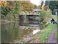
Angling on the River Wey
Autumnal scene by Bowers Lane in Guildford's eastern suburb of Burpham. The first bridge is a footbridge; the farther bridge carries Clay Lane traffic.
Image: © Colin Smith
Taken: 31 Oct 2007
0.04 miles