IMAGES TAKEN NEAR TO
Dunlin Rise, GUILDFORD, GU4 7DX
Introduction
This page details the photographs taken nearby to Dunlin Rise, GU4 7DX by members of the Geograph project.
The Geograph project started in 2005 with the aim of publishing, organising and preserving representative images for every square kilometre of Great Britain, Ireland and the Isle of Man.

There are currently over 7.5m images from over14,400 individuals and you can help contribute to the project by visiting https://www.geograph.org.uk
Image Map
Images are licensed for reuse under creativecommons.org/licenses/by-sa/2.0
Notes
- Clicking on the map will re-center to the selected point.
- The higher the marker number, the further away the image location is from the centre of the postcode.
Image Listing (61 Images Found)
Images are licensed for reuse under creativecommons.org/licenses/by-sa/2.0
Image
Details
Distance
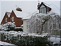
1
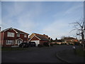
Dunlin Rise, Merrow Park
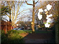
"Snow berries" overhanging the footpath which parallels Partridge Way. There is a dense network of paths on this Guildford housing estate which take pedestrians away from the roads.
Image: © Colin Smith
Taken: 16 Dec 2007
0.01 miles
2
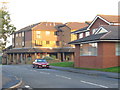
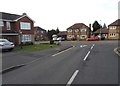
Merrow Park
At the centre of this 1980s Guildford housing estate. On the left is a block of flats with local shops at ground level. On the right is Merrow Park Surgery. The street is Kingfisher Drive.
Image: © Colin Smith
Taken: 2 Nov 2008
0.05 miles
3
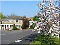
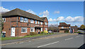
Partridge Way, Merrow Park
Spring in the Guildford suburbs. Merrow Park has many large detached houses with small gardens. Many of the houses are also built in mock classical (like this one) or mock Tudor styles. The cul-de-sacs off Partridge Way are also named after birds.
Image: © Colin Smith
Taken: 15 Apr 2007
0.05 miles
4
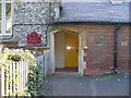
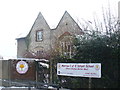
Merrow School
Ornate doorway into the Merrow Church of England Infants School on Merrow Street. A school was first built here in 1853. Now much extended, it mainly caters for children from Merrow, including the 1980s Merrow Park housing estate. This is a feeder school for Bushy Hill Junior School.
Image: © Colin Smith
Taken: 17 Feb 2008
0.06 miles
6
Partridge Way at the junction of Kingfisher Drive
Image: © David Howard
Taken: 14 Feb 2016
0.07 miles
7
Merrow C of E Infant School
Original flint-built block of Merrow First School. Now largely serves modern housing estates.
Image: © Colin Smith
Taken: 5 Feb 2012
0.07 miles
9
Cottages on Merrow Street
Cottages with distinctive diamond pattern brickwork. The old village street is now swamped by suburban Merrow Park.
Image: © Colin Smith
Taken: 6 Apr 2008
0.08 miles
10
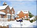
Merrow Street
Snowy Guildford. Merrow Street, with its old and new cottages, is now a cul-de-sac. Formerly, it was the main road north from Merrow village centre - but now it is no longer a through road being cut by Kingfisher Drive, the main road in the 1980s Merrow Park housing estate.
Note the familiar Surrey diamond pattern in the brickwork of Salisbury Cottage.
Image: © Colin Smith
Taken: 3 Feb 2009
0.09 miles