IMAGES TAKEN NEAR TO
Ripplesmore Close, SANDHURST, GU47 8PE
Introduction
This page details the photographs taken nearby to Ripplesmore Close, GU47 8PE by members of the Geograph project.
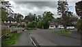
The Geograph project started in 2005 with the aim of publishing, organising and preserving representative images for every square kilometre of Great Britain, Ireland and the Isle of Man.

There are currently over 7.5m images from over14,400 individuals and you can help contribute to the project by visiting https://www.geograph.org.uk
Image Map
Images are licensed for reuse under creativecommons.org/licenses/by-sa/2.0
Notes
- Clicking on the map will re-center to the selected point.
- The higher the marker number, the further away the image location is from the centre of the postcode.
Image Listing (46 Images Found)
Images are licensed for reuse under creativecommons.org/licenses/by-sa/2.0
Image
Details
Distance
1
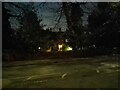
Longdown Lodge at night
Longdown Lodge was a large stately home built after the arrival of the railway in Sandhurst in 1849. This house was built around the 1860s with the development of the area with Broadmoor Asylum and Wellington College being built. It is one of the few large houses to remain in Sandhurst, with most being demolished for the land to be redeveloped.
The gardens of Longdown Lodge were developed in the 1950s to form the Longdown Lodge Estate, which is to the north. Roads such as Greenways, Beech Ride and Broom Acres are part of this estate. The lodge itself has been converted into flats.
Image: © Oscar Taylor
Taken: 28 Mar 2023
0.04 miles
2
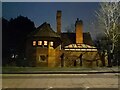
82 Crowthorne Road at night
A house next to Longdown Lodge Image], perhaps originally part of the lodge or ancillary accommodation as it shares the same architectural style. The house is built into its retaining wall on Crowthorne Road.
Image: © Oscar Taylor
Taken: 28 Mar 2023
0.06 miles
3
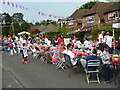
Royal Wedding Celebrations, Broom Acres
A street party on Broom Acres on the Longdown Lodge Estate in Sandhurst, to celebrate the Royal Wedding on Prince William and Kate Middleton.
Image: © Oscar Taylor
Taken: 29 Apr 2011
0.07 miles
4
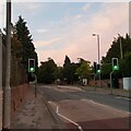
Crowthorne Road, Sandhurst
Crowthorne Road, Sandhurst, with a view towards Crowthorne, showing a pedestrian crossing with traffic lights and a bus stop.
Image: © Oscar Taylor
Taken: 8 Aug 2020
0.08 miles
5
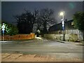
Junction to Wellington Road at night
The one way section and junction to Wellington Road off Crowthorne Road in Sandhurst. This section of the road used to be open in both directions with a priority to traffic from Crowthorne Road, but after numerous accidents it was changed to one way.
If the large white wall to the right was demolished (there is a pavement behind leading to the gates of the properties there) and the road expanded, it could be used as a two way street, although it is likely a traffic calming measure nowadays to prevent it being used as a bypass to avoid the high street.
Image: © Oscar Taylor
Taken: 28 Mar 2023
0.09 miles
6
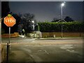
Stop on Harts Leap Road at night
Looking past the stop sign on Harts Leap Road, over Crowthorne Road to Wellington Road. The junction is quite difficult to exit as there are high fences on both sides.
Image: © Oscar Taylor
Taken: 28 Mar 2023
0.09 miles
7
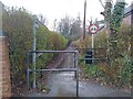
Calvert Walk
A footpath between the corner of Beech Ride and Orchard Gate, and Wellington Road.
The footpath is called Calvert Walk as underneath it (and under most of the Longdown Lodge Estate) is a culvert or underwater stream, which appears in ditches on Wellington Road. During heavy rainfall such as the day this photograph was taken, the lower half of the footpath becomes part of the stream, as water spurts from below.
Image: © Oscar Taylor
Taken: 31 Mar 2023
0.10 miles
8
Harts Leap Close
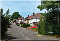
On a gentle slope, the north side of the Blackwater Valley.
Image: © Des Blenkinsopp
Taken: 18 May 2022
0.10 miles
9
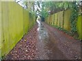
Flooded Calvert Walk
Flooding on Calvert Walk - a footpath between the corner of Beech Ride and Orchard Gate, and Wellington Road - following heavy rain.
The footpath is called Calvert Walk as underneath it (and under most of the Longdown Lodge Estate) is a culvert or underwater stream, which appears in ditches on Wellington Road. During heavy rainfall such as the day this photograph was taken, the lower half of the footpath becomes part of the stream, as water spurts from below the path and rushes down to Wellington Road.
Image: © Oscar Taylor
Taken: 31 Mar 2023
0.10 miles