IMAGES TAKEN NEAR TO
Branson Road, BORDON, GU35 0FB
Introduction
This page details the photographs taken nearby to Branson Road, GU35 0FB by members of the Geograph project.
The Geograph project started in 2005 with the aim of publishing, organising and preserving representative images for every square kilometre of Great Britain, Ireland and the Isle of Man.

There are currently over 7.5m images from over14,400 individuals and you can help contribute to the project by visiting https://www.geograph.org.uk
Image Map
Images are licensed for reuse under creativecommons.org/licenses/by-sa/2.0
Notes
- Clicking on the map will re-center to the selected point.
- The higher the marker number, the further away the image location is from the centre of the postcode.
Image Listing (13 Images Found)
Images are licensed for reuse under creativecommons.org/licenses/by-sa/2.0
Image
Details
Distance
1
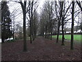
Avenue of trees in Jubilee Park
Jubilee Park, named after the year it was opened, 1977 Queens Silver Jubilee. This avenue of trees runs parallel with Mill Chase Rd
Image: © easthantsxc
Taken: 24 Jan 2016
0.05 miles
2
Shipwrights' Way 41
Dead Water is crossed and the Local Nature Reserve is on the left.
Image: © Shazz
Taken: 21 Aug 2016
0.06 miles
3

New boardwalk Bordon Loop
A new section of boardwalk laid down near Mill Chase road on what will the new Bordon Loop, a 7 mile track suitable for walkers and cyclists
Image: © easthantsxc
Taken: 24 Jan 2015
0.08 miles
4

Shipwrights' Way 42
The Way turns into Hollybrook Park.
Image: © Shazz
Taken: 21 Aug 2016
0.08 miles
5
Shipwrights' Way 40
The end of Waterside Close is crossed.
Image: © Shazz
Taken: 21 Aug 2016
0.09 miles
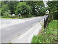
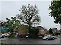
6
Traffic Calming, Bordon
The road is Chalet Hill or Mill Chase Road - the name changes somewhere around here. It is not a through route to Lindford, although it seems so on the map.
Image: © Robin Webster
Taken: 31 Mar 2007
0.10 miles
7
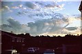
Unusual Cloud Formation
I expect there is a technical term for this unusual cloud formation which I photographed one evening in Rivermede, Bordon, Hants. in 1980.
Image: © Clive Warneford
Taken: Unknown
0.14 miles
8
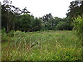
Clearing, Alexandria Park
Clearing in Alexandria Park (Bordon Inclosure) which is managed by Deadwater Valley Trust. Photo taken from footpath which runs east-west across the middle of the clearing, from near the Rifle Wall. The trees at the far end are located by the allotments on Savile Crescent.
Image: © BHelas
Taken: 30 Jun 2016
0.16 miles
9
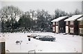
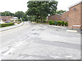
Snowy morning in Bordon.
This view of Waterside Close, off Mill Chase Road, Bordon was taken on a wintry day in 1982.
Image: © Clive Warneford
Taken: Unknown
0.17 miles
10
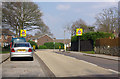
2016: a year on Geograph (Day 132)
Junction of Waterside Close and Beaver Mews
Image: © Basher Eyre
Taken: 11 May 2016
0.18 miles