IMAGES TAKEN NEAR TO
Savile Crescent, BORDON, GU35 0EE
Introduction
This page details the photographs taken nearby to Savile Crescent, GU35 0EE by members of the Geograph project.
The Geograph project started in 2005 with the aim of publishing, organising and preserving representative images for every square kilometre of Great Britain, Ireland and the Isle of Man.

There are currently over 7.5m images from over14,400 individuals and you can help contribute to the project by visiting https://www.geograph.org.uk
Image Map
Images are licensed for reuse under creativecommons.org/licenses/by-sa/2.0
Notes
- Clicking on the map will re-center to the selected point.
- The higher the marker number, the further away the image location is from the centre of the postcode.
Image Listing (31 Images Found)
Images are licensed for reuse under creativecommons.org/licenses/by-sa/2.0
Image
Details
Distance
1
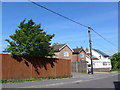
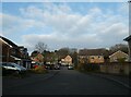
2016: a year on Geograph (Day 130)
Houses in Savile Crescent
Image: © Basher Eyre
Taken: 9 May 2016
0.06 miles
2
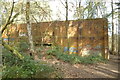
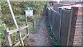
Alexandra Park Rifle Wall
Rifle Wall in Alexandra Park/Bordon Inclosure nature reserve. Easily accessible from Savile Crescent. Previously used by the Army. A small pond is located on the other side.
Image: © BHelas
Taken: 15 Mar 2016
0.08 miles
3
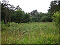
Clearing, Alexandria Park
Clearing in Alexandria Park (Bordon Inclosure) which is managed by Deadwater Valley Trust. Photo taken from footpath which runs east-west across the middle of the clearing, from near the Rifle Wall. The trees at the far end are located by the allotments on Savile Crescent.
Image: © BHelas
Taken: 30 Jun 2016
0.10 miles
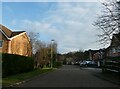
4
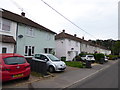
Looking north-northeast in Maple Leaf Drive
Image: © Basher Eyre
Taken: 21 Dec 2021
0.14 miles
6
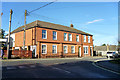
Block on Forest Road, Bordon
This is probably residential, although hard to tell, apart from the right hand end. It has recently been renovated, and the upper floor tiling at the near end is new, over brick.
Image: © Robin Webster
Taken: 11 Feb 2016
0.16 miles
7

Derelict house in Bordon
This house has since been knocked down and redeveloped.
Image: © easthantsxc
Taken: 18 Mar 2002
0.16 miles
8
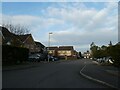
Looking north-northeast along Canada Way
Image: © Basher Eyre
Taken: 21 Dec 2021
0.16 miles
9
Entrance to Deadwater Valley Nature Reserve
This footpath is the entrance to Deadwater Valley Nature Reserve directly from the A325 that runs through Bordon.
Image: © John P Reeves
Taken: 25 Sep 2018
0.17 miles