IMAGES TAKEN NEAR TO
Miller Lane, ALTON, GU34 4FE
Introduction
This page details the photographs taken nearby to Miller Lane, GU34 4FE by members of the Geograph project.
The Geograph project started in 2005 with the aim of publishing, organising and preserving representative images for every square kilometre of Great Britain, Ireland and the Isle of Man.

There are currently over 7.5m images from over14,400 individuals and you can help contribute to the project by visiting https://www.geograph.org.uk
Image Map (Loading...)


Getting Data...Please wait
Leaflet Map data © OpenStreetMap
Images are licensed for reuse under creativecommons.org/licenses/by-sa/2.0
Notes
- Clicking on the map will re-center to the selected point.
- The higher the marker number, the further away the image location is from the centre of the postcode.
Image Listing (158 Images Found)
Images are licensed for reuse under creativecommons.org/licenses/by-sa/2.0
Image
Details
Distance

2
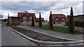
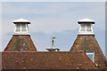
Old Treloar School Site Redevelopment
The School has moved from the village. A major new development has been turning the site to new uses, mainly housing.
Linden Homes - http://www.lindenhomes.co.uk/developments/hampshire/froyle-park-upper-froyle
Image: © James Emmans
Taken: 9 Apr 2016
0.03 miles
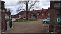
5
View Towards Froyle Place
Froyle Place is part of the Treloar School which currently occupies this corner of Upper Froyle. Froyle Place, itself, has a long history.
http://www.froyle.com/fp.htm
Image: © Peter Trimming
Taken: 2 Jan 2010
0.07 miles
7

St Swithun?s Way signs, Upper Froyle
The St Swithun’s Way runs for 34 miles between Winchester in Hampshire and Farnham in Surrey. The waymarker for the route shows a green arrow with a shell and two croziers on a white circular background. The waymarked route is generally considered to be the first part of the historical Pilgrim’s Way since it links up with the North Downs Way at Farnham. St Swithun, who the route is named after, was born in Winchester.
Image: © Peter S
Taken: 12 Sep 2017
0.08 miles
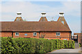
8
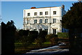
Froyle House, Upper Froyle, Hampshire
Froyle House is currently used as the headquarters of the Treloar Trust. See the link for a history of the house.
http://www.froyle.com/fh.htm
Image: © Peter Trimming
Taken: 2 Jan 2010
0.08 miles
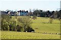
9
Road junction, Upper Froyle
Upper Froyle is a village in east Hampshire and is passed through on the St Swithun’s Way which coincides with part of the much longer Pilgrim’s Way.
Image: © Peter S
Taken: 12 Sep 2017
0.08 miles
10
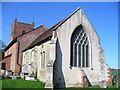
Froyle Church
St Mary's is the ancient parish church in the village of Upper Froyle.
www.froyle.com
Image: © Colin Smith
Taken: 9 Apr 2011
0.08 miles