IMAGES TAKEN NEAR TO
Medstead Road, ALTON, GU34 4AF
Introduction
This page details the photographs taken nearby to Medstead Road, GU34 4AF by members of the Geograph project.
The Geograph project started in 2005 with the aim of publishing, organising and preserving representative images for every square kilometre of Great Britain, Ireland and the Isle of Man.

There are currently over 7.5m images from over14,400 individuals and you can help contribute to the project by visiting https://www.geograph.org.uk
Image Map
Images are licensed for reuse under creativecommons.org/licenses/by-sa/2.0
Notes
- Clicking on the map will re-center to the selected point.
- The higher the marker number, the further away the image location is from the centre of the postcode.
Image Listing (15 Images Found)
Images are licensed for reuse under creativecommons.org/licenses/by-sa/2.0
Image
Details
Distance
1
Wellhouse Road, Beech
Hedgerow-lined village lane in Beech where most of the 1920s colonial style bungalows of corrugated iron / tin / wood have now long been replaced by modern dwellings.
http://en.wikipedia.org/wiki/Beech,_Hampshire
Image: © Colin Smith
Taken: 1 Feb 2012
0.11 miles
2
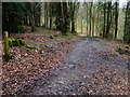
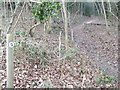
Path in Bushy Leaze Wood
Heading towards Beech, in woodland with much Beech.
Image: © Robin Webster
Taken: 13 May 2014
0.11 miles
3
Village Lane in Beech
This is an active village see http://www.beechvillage.org.uk/the_village.asp. This lane is residential and most of the houses are quite large.
Image: © Graham Clutton
Taken: 8 Apr 2006
0.11 miles
4
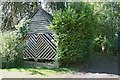
Donkey wellhouse, Wellhouse Road
This small square wooden building with a slate roof is not a garage, but a grade II listed donkey wellhouse, situated at Beech Barns, towards the end of Wellhouse Road, and dating perhaps from the late C18. A donkey wheel and winch can be seen within, through the slatted panel, together with a cover over the well shaft. The well is reported to be 60m deep.
Image: © Hugh Craddock
Taken: 13 Oct 2012
0.12 miles
5
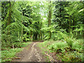
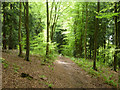
Beech, Woodland Path
Entering deciduous woodland off Medstead Road. Here is Park Pale, the edge of woodland once owned by the Bishops of Winchester.
http://en.wikipedia.org/wiki/Beech,_Hampshire
Image: © Colin Smith
Taken: 1 Feb 2012
0.12 miles
6
Path in Bushy Leaze Wood
Beech is the nearby village, Beech is the principal tree.
Image: © Robin Webster
Taken: 13 May 2014
0.15 miles
7
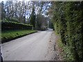
Beech, Off Medstead Road
Lane in the quiet village of Beech, east of Alton. Colonial style houses of wood and corrugated iron / tin have now largely been replaced by modern housing.
http://en.wikipedia.org/wiki/Beech,_Hampshire
Image: © Colin Smith
Taken: 1 Feb 2012
0.16 miles
8
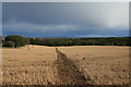
Cross-field footpath to Beech
Public footpath Beech 703 descends through a ploughed field towards Wellhouse Lane. This is a remarkably long cross-field footpath, at over 550m, and it is just as well that it has been clearly defined through the summer's cultivation, though it is not always so: see Image
Image: © Hugh Craddock
Taken: 13 Oct 2012
0.17 miles
9
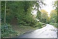
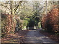
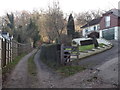
Bottom of Wellhouse Lane
Medstead Road opposite the entrance to the Forestry Commission's Bushy Leaze Wood. To the left is the bottom of Wellhouse Lane, which shows signs of having been tarred in the distant past, but which is now unsurfaced and unsuitable for motor traffic.
Image: © Hugh Craddock
Taken: 13 Oct 2012
0.18 miles