IMAGES TAKEN NEAR TO
White Hart Lane, GUILDFORD, GU3 3EA
Introduction
This page details the photographs taken nearby to White Hart Lane, GU3 3EA by members of the Geograph project.
The Geograph project started in 2005 with the aim of publishing, organising and preserving representative images for every square kilometre of Great Britain, Ireland and the Isle of Man.

There are currently over 7.5m images from over14,400 individuals and you can help contribute to the project by visiting https://www.geograph.org.uk
Image Map
Images are licensed for reuse under creativecommons.org/licenses/by-sa/2.0
Notes
- Clicking on the map will re-center to the selected point.
- The higher the marker number, the further away the image location is from the centre of the postcode.
Image Listing (33 Images Found)
Images are licensed for reuse under creativecommons.org/licenses/by-sa/2.0
Image
Details
Distance
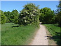
1
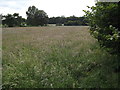
Grassland by Hook Farm
Large grassy meadow by Broadstreet Common, Wood Street Village.
Image: © Colin Smith
Taken: 20 Jun 2012
0.05 miles
2
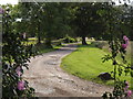
By Hook Farm
Loose / light surfaced lane in Wood Street Village, west of Guildford.
Image: © Colin Smith
Taken: 20 Jun 2012
0.06 miles
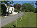
3
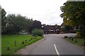
Wood Street Village
House and a pub cluster along what is now a bridleway leading off from the west end of Wood Street Village green, suggesting that this was once a more important route than it is today.
Image: © Ron Strutt
Taken: 26 Sep 2005
0.09 miles
4
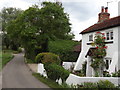
White Hart Lane
Narrow lane heading west from Wood Street Village and the White Hart pub. The old buttressed cottage here carries a date of 1672 on its wall.
http://en.wikipedia.org/wiki/Wood_Street_Village
Image: © Colin Smith
Taken: 20 Jun 2012
0.09 miles
5
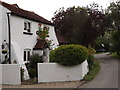
White Hart Lane 1672
Historic cottage carrying a date of 1672 on its wall, Wood Street Village.
http://en.wikipedia.org/wiki/Wood_Street_Village
Image: © Colin Smith
Taken: 20 Jun 2012
0.09 miles
6
White Hart Lane, Woodstreet
The lane is named after the pub which is just beyond the cottage. The cottage has a plaster plaque with the date 1672 between the upper windows.
Image: © Alan Hunt
Taken: 2 May 2011
0.10 miles
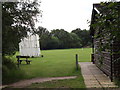
7
Backside Common, Woodstreet
The continuation of White Hart Lane that runs towards Woodstreet cricket pitch on Backside Common
Image: © Alan Hunt
Taken: 2 May 2011
0.10 miles
8
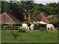
Grazing Calves
Young cattle in Wood Street Village with roofs of Frog Grove Lane behind them.
Image: © Colin Smith
Taken: 20 Jun 2012
0.14 miles
9
Pitchside, White Hart Lane
Not the more famous Tottenham Hotspur football ground but the cricket field off White Hart Lane in Wood Street Village, west of Guildford.
Image: © Colin Smith
Taken: 20 Jun 2012
0.14 miles
10

White Hart Public House, Wood Street Village
Seen from the White Hart Public House car park.
Image: © Christine Matthews
Taken: 8 Aug 2021
0.17 miles