IMAGES TAKEN NEAR TO
Winchester Road, PETERSFIELD, GU32 3PB
Introduction
This page details the photographs taken nearby to Winchester Road, GU32 3PB by members of the Geograph project.
The Geograph project started in 2005 with the aim of publishing, organising and preserving representative images for every square kilometre of Great Britain, Ireland and the Isle of Man.

There are currently over 7.5m images from over14,400 individuals and you can help contribute to the project by visiting https://www.geograph.org.uk
Image Map (Loading...)


Getting Data...Please wait
Leaflet Map data © OpenStreetMap
Images are licensed for reuse under creativecommons.org/licenses/by-sa/2.0
Notes
- Clicking on the map will re-center to the selected point.
- The higher the marker number, the further away the image location is from the centre of the postcode.
Image Listing (11 Images Found)
Images are licensed for reuse under creativecommons.org/licenses/by-sa/2.0
Image
Details
Distance
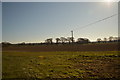
1
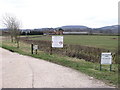
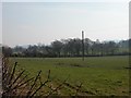
Looking South across fields towards Butser Hill
Image: © Martyn Pattison
Taken: 5 Apr 2020
0.10 miles
2
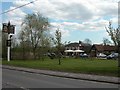
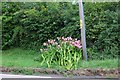
Entrance to Newbuildings Farm, Stroud, Hants
Image: © nick macneill
Taken: 9 Mar 2010
0.14 miles
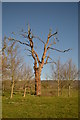
5
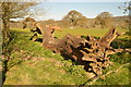
Trees in varying stages of the lifecycle
One dead tree, one collapsed which has been overgrown with brambles, one not looking too well, and two looking healthy and strong.
Image: © Martyn Pattison
Taken: 5 Apr 2020
0.22 miles
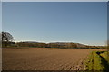
7
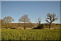
Farmland south of the A272 at Stroud
The A272 cuts through farmland to the West of Petersfield, this photo was taken from Langrish School looking south towards Butser Hill
Image: © Martyn Pattison
Taken: 16 Mar 2005
0.23 miles