IMAGES TAKEN NEAR TO
Dellfield, PETERSFIELD, GU32 1EH
Introduction
This page details the photographs taken nearby to Dellfield, GU32 1EH by members of the Geograph project.
The Geograph project started in 2005 with the aim of publishing, organising and preserving representative images for every square kilometre of Great Britain, Ireland and the Isle of Man.

There are currently over 7.5m images from over14,400 individuals and you can help contribute to the project by visiting https://www.geograph.org.uk
Image Map
Images are licensed for reuse under creativecommons.org/licenses/by-sa/2.0
Notes
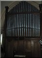
- Clicking on the map will re-center to the selected point.
- The higher the marker number, the further away the image location is from the centre of the postcode.
Image Listing (52 Images Found)
Images are licensed for reuse under creativecommons.org/licenses/by-sa/2.0
Image
Details
Distance
1
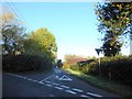
Looking from High Cross Lane into Privett Road
Image: © Basher Eyre
Taken: 21 Oct 2018
0.13 miles
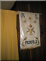
3
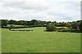
Froxfield 28
View north-east to Blackmore Farm from footpath Froxfield 28. The footpath passes just to the left of the corner of Green Slade, the garden enclosure on the right.
Image: © Hugh Craddock
Taken: 26 Jul 2009
0.15 miles
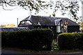
4
Postbox outside Froxfield Primary School
Image: © Basher Eyre
Taken: 21 Oct 2018
0.16 miles
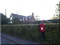
6
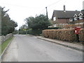
Postbox opposite St Peter's, High Cross
Image: © Basher Eyre
Taken: 28 Feb 2009
0.16 miles
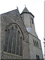
9

Superb stained glass windows on the north wall at St Peter's, High Cross
Image: © Basher Eyre
Taken: 28 Feb 2009
0.17 miles
10
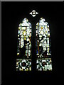
Intricate stained glass window on the north wall at St Peter's, High Cross
Image: © Basher Eyre
Taken: 28 Feb 2009
0.17 miles