IMAGES TAKEN NEAR TO
Stoner Hill Road, PETERSFIELD, GU32 1DX
Introduction
This page details the photographs taken nearby to Stoner Hill Road, GU32 1DX by members of the Geograph project.
The Geograph project started in 2005 with the aim of publishing, organising and preserving representative images for every square kilometre of Great Britain, Ireland and the Isle of Man.

There are currently over 7.5m images from over14,400 individuals and you can help contribute to the project by visiting https://www.geograph.org.uk
Image Map
Images are licensed for reuse under creativecommons.org/licenses/by-sa/2.0
Notes
- Clicking on the map will re-center to the selected point.
- The higher the marker number, the further away the image location is from the centre of the postcode.
Image Listing (8 Images Found)
Images are licensed for reuse under creativecommons.org/licenses/by-sa/2.0
Image
Details
Distance
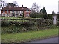
2
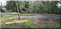
Old Lane at Stoner Hill
This private lane is shown on the 1895 OS map and appears to have offered an alternative or older route (now unused) to the modern surfaced road coming up the hill from Petersfield.
Image: © Paul Collins
Taken: 27 Jan 2019
0.08 miles
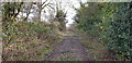
3
Footpath at Stoner Hill
This view is taken from the start of the footpath at its junction with the lane. It cuts the corner of the lane off.
Image: © Paul Collins
Taken: 27 Jan 2019
0.09 miles
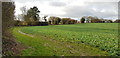
5
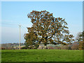
Oak, Stoner Hill
This is nearly at the highest point in this district, shown as a spot height of 235 m in the same field just to the left.
Image: © Robin Webster
Taken: 26 Nov 2013
0.10 miles
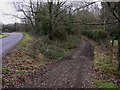
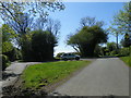
6
Byway from Stoner Hill
Here a byway loops off the metalled lane and from the loop drops down (centre view) through Ashford Hanger towards Steep.
Image: © Paul Collins
Taken: 27 Jan 2019
0.12 miles
7
Junction of Broad Way and Ridge Top Lane
Image: © Martyn Pattison
Taken: 19 Apr 2020
0.22 miles
8
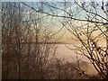
South Downs from Stoner Hill across a sea of mist
In this shot the sun has just risen above the mist filling the region between the Hangers and the Downs. Climbing the hill, it was noticeably warmer when we passed the boundary of the temperature inversion.
Image: © Keith Rose
Taken: 20 Nov 2005
0.25 miles