IMAGES TAKEN NEAR TO
Fitzlea Wood Road, PETWORTH, GU28 0QN
Introduction
This page details the photographs taken nearby to Fitzlea Wood Road, GU28 0QN by members of the Geograph project.
The Geograph project started in 2005 with the aim of publishing, organising and preserving representative images for every square kilometre of Great Britain, Ireland and the Isle of Man.

There are currently over 7.5m images from over14,400 individuals and you can help contribute to the project by visiting https://www.geograph.org.uk
Image Map
Images are licensed for reuse under creativecommons.org/licenses/by-sa/2.0
Notes
- Clicking on the map will re-center to the selected point.
- The higher the marker number, the further away the image location is from the centre of the postcode.
Image Listing (21 Images Found)
Images are licensed for reuse under creativecommons.org/licenses/by-sa/2.0
Image
Details
Distance
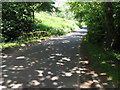
1
Barn by The Serpent Trail
Public bridleway 1004. The Serpent Trail is a 64 mile long distance footpath from Haslemere to Petersfield. The route is designed to join up the many heathland areas on greensand in the western Weald.
Image: © Peter Holmes
Taken: 16 Apr 2016
0.02 miles
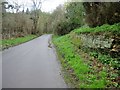
2
Barnett's Bridge north of Upper Norwood
Image: © Dave Spicer
Taken: 26 Jun 2010
0.03 miles
3
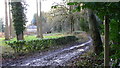
Cottages on bridleway
These cottages are on Graffham Common.
Image: © Shazz
Taken: 5 Dec 2008
0.03 miles
4
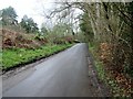
The Serpent Trail in Fitzlea Wood
The Serpent Trail is a 64 mile long distance footpath from Haslemere to Petersfield. The route is designed to join up the many heathland areas on greensand in the western Weald.
Image: © Peter Holmes
Taken: 16 Apr 2016
0.03 miles
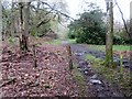
5
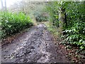
Muddy section of The Serpent Trail
Public bridleway 1004 to Graffham Common. The Serpent Trail is a 64 mile long distance footpath from Haslemere to Petersfield. The route is designed to join up the many heathland areas on greensand in the western Weald.
Image: © Peter Holmes
Taken: 16 Apr 2016
0.07 miles
6
Crumbling retaining wall by The Serpent Trail
The Serpent Trail is a 64 mile long distance footpath from Haslemere to Petersfield. The route is designed to join up the many heathland areas on greensand in the western Weald.
Image: © Peter Holmes
Taken: 16 Apr 2016
0.10 miles
7
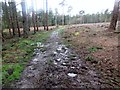
Felled area, Graffham Common
Public bridleway 1004.
Image: © Peter Holmes
Taken: 16 Apr 2016
0.11 miles
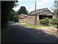
9
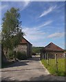
At Brookside Farm
The farm would seem to take its name from a tributary of the River Rother, which flows nearby.
Though it isn't immediately obvious, there is a contrast in building materials here - the smaller building is of local sandstone (Bargate stone, perhaps) while the larger one is brick-built.
Image: © Stefan Czapski
Taken: 4 Jul 2015
0.13 miles
10
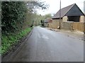
Rebuilt barn at Brookside Farm
The Serpent Trail passes Brookside Farm. See previous photo Image The Serpent Trail is a 64 mile long distance footpath from Haslemere to Petersfield. The route is designed to join up the many heathland areas on greensand in the western Weald.
Image: © Peter Holmes
Taken: 16 Apr 2016
0.14 miles