IMAGES TAKEN NEAR TO
Brook Lane, WOKING, GU23 7EH
Introduction
This page details the photographs taken nearby to Brook Lane, GU23 7EH by members of the Geograph project.
The Geograph project started in 2005 with the aim of publishing, organising and preserving representative images for every square kilometre of Great Britain, Ireland and the Isle of Man.

There are currently over 7.5m images from over14,400 individuals and you can help contribute to the project by visiting https://www.geograph.org.uk
Image Map
Images are licensed for reuse under creativecommons.org/licenses/by-sa/2.0
Notes
- Clicking on the map will re-center to the selected point.
- The higher the marker number, the further away the image location is from the centre of the postcode.
Image Listing (30 Images Found)
Images are licensed for reuse under creativecommons.org/licenses/by-sa/2.0
Image
Details
Distance
1
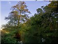
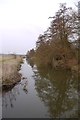
Along the Broadmead Cut in November
Photo taken on November 11th, and for the moment the picture is still quite green. The leaning tree on the near bank is an alder (and a pretty typical specimen); on the far bank alders mingle with oaks.
Image: © Stefan Czapski
Taken: 11 Nov 2016
0.07 miles
2
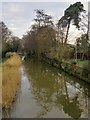
The Wey Navigation in January: view downstream from the Tanyard Bridge
Photo taken on a dull January afternoon, and the scene is much as it was when I was here the previous April http://www.geograph.org.uk/photo/3414574 But the sharpness of the reflections shows that this time there was no rain, and very little wind.
Image: © Stefan Czapski
Taken: 20 Jan 2014
0.08 miles
3
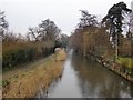
The Wey Navigation in rain: view downstream from the Tanyard Bridge
A few houses back on to the canal at this point. Behind the camera is the former tannery site, now Send Business Park.
Image: © Stefan Czapski
Taken: 10 Apr 2013
0.08 miles
4
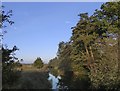
Broadmead Cut in March
View downstream (north-eastwards) from the Tanyard Bridge. Nearly all the trees are alders.
Image: © Stefan Czapski
Taken: 16 Mar 2014
0.09 miles
5
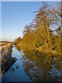
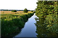
Broadmead Cut: view north-east from the Tanyard Bridge in early April
The River Wey flows through this stretch of its flood-plain in a number of channels - including the heavily engineered cuts of the Wey Navigations. The marshy area to the left is known as Broadmead, and this channel as Broadmead Cut.
At this time of year alder trees contribute subtle colours to the landscape - the cones and catkins showing brown and purplish.
Image: © Stefan Czapski
Taken: 10 Apr 2013
0.09 miles
6
Broadmead Cut in November: the view from the Tanyard Bridge
Looking downstream (north-east) from the bridge.
Image and Image were taken from much the same spot, but at times of year when the trees were leafless.
Image: © Stefan Czapski
Taken: 11 Nov 2016
0.09 miles
8
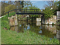
Tannery Bridge, Send
Tannery bridge over the River Wey Navigation near the site of the former tannery. To the north are the Broadmead watermeadows.
Image: © Alan Hunt
Taken: 2 May 2013
0.10 miles
9
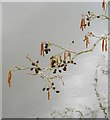
Alder catkins and 'cones', by the Tanyard Bridge
The tree overhangs the Broadmead Cut. In early spring catkins and the remains of last year's fruit - hanging side by side - give the canopy of the tree a particular texture and colour, so that an alder is easily recognisable at a distance.
The alder, Alnus glutinosa, is a hardwood tree, not a conifer, so its fruit should not - strictly speaking - be termed cones; nonetheless, they do rather resemble miniature larch cones - hence the 'cones' in my title for this item.
Image: © Stefan Czapski
Taken: 11 Apr 2013
0.12 miles
10
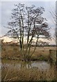
Alder tree by the Tanyard Bridge, in January
Growing on the bank of the Broadmead Cut.
Image: © Stefan Czapski
Taken: 20 Jan 2014
0.12 miles