IMAGES TAKEN NEAR TO
Riverside Avenue, LIGHTWATER, GU18 5RU
Introduction
This page details the photographs taken nearby to Riverside Avenue, GU18 5RU by members of the Geograph project.
The Geograph project started in 2005 with the aim of publishing, organising and preserving representative images for every square kilometre of Great Britain, Ireland and the Isle of Man.

There are currently over 7.5m images from over14,400 individuals and you can help contribute to the project by visiting https://www.geograph.org.uk
Image Map
Images are licensed for reuse under creativecommons.org/licenses/by-sa/2.0
Notes
- Clicking on the map will re-center to the selected point.
- The higher the marker number, the further away the image location is from the centre of the postcode.
Image Listing (36 Images Found)
Images are licensed for reuse under creativecommons.org/licenses/by-sa/2.0
Image
Details
Distance
1
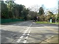
Lightwater: Guildford Road
This is Guildford Road, once the A322, at the junction with Riverside Avenue.
Riverside is perhaps a misnomer as the only watercourse in the vicinity is a small stream, barely a metre wide, that discharges from a lake on the left side of the road, under the road, through the Riverside Avenue estate and down under the A322 Lightwater Bypass to join Windle Brook. The green cabinet on the right contains an Environment Agency gauging station that would warn of dangerously high or fast water flows from the lake that could potentially cause a flood event in the estate downstream.
Image: © Nigel Cox
Taken: 28 Feb 2016
0.10 miles
2
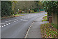
Guildford Road, Lightwater
Looking northeast towards the Heronscourt junction from the crest of the rise near Turf Hill.
Image: © Alan Hunt
Taken: 25 Nov 2015
0.10 miles
3
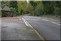
Guidford Road, Lightwater
Looking southeast along Guildford Road with the Springfield junction on the left.
Image: © Alan Hunt
Taken: 25 Nov 2015
0.12 miles
4
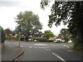
Lightwater Road at the junction of Guildford Road
Image: © David Howard
Taken: 27 Jul 2015
0.13 miles
5
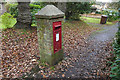
Postbox on Blackstroud Lane West
The George VI post box on the walkway along the northern side of Blackstroud Lane West.
Image: © Alan Hunt
Taken: 25 Nov 2015
0.15 miles
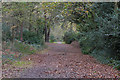
6
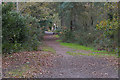
Turf Hill, Lightwater
The track running along the northern edge of Turf Hill, an area of heathland between the Red Road and Lightwater Village.
Image: © Alan Hunt
Taken: 25 Nov 2015
0.15 miles
7
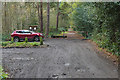
Turf Hill car park, Lightwater
The car park off the Guildford Road in Lightwater with the track along the northern edge of this area of heathland.
Image: © Alan Hunt
Taken: 25 Nov 2015
0.15 miles
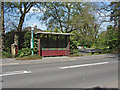
8
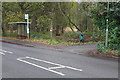
Bus stop, Guildford Road
The bus stop on the west side of the Guildford Road with the entrance to the Turf Hill car park.
Image: © Alan Hunt
Taken: 25 Nov 2015
0.15 miles
9
Guildford Road, Lightwater
The bus stop opposite the Turf Hill car park on the Guildford Road.
Image: © Alan Hunt
Taken: 7 May 2013
0.16 miles
10
Turf Hill, Lightwater
Looking northwest along the track that marks the southern edge of Lightwater village. Off to the left is an area of open heathland.
Image: © Alan Hunt
Taken: 25 Nov 2015
0.16 miles