IMAGES TAKEN NEAR TO
Hillside, CAMBERLEY, GU15 4NU
Introduction
This page details the photographs taken nearby to Hillside, GU15 4NU by members of the Geograph project.
The Geograph project started in 2005 with the aim of publishing, organising and preserving representative images for every square kilometre of Great Britain, Ireland and the Isle of Man.

There are currently over 7.5m images from over14,400 individuals and you can help contribute to the project by visiting https://www.geograph.org.uk
Image Map
Images are licensed for reuse under creativecommons.org/licenses/by-sa/2.0
Notes
- Clicking on the map will re-center to the selected point.
- The higher the marker number, the further away the image location is from the centre of the postcode.
Image Listing (4 Images Found)
Images are licensed for reuse under creativecommons.org/licenses/by-sa/2.0
Image
Details
Distance
1
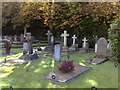
The Cemetery at the Royal Military Academy, Sandhurst
Image: © Siobhan Brennan-Raymond
Taken: 11 Oct 2008
0.10 miles
2
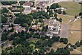
Sandhurst Royal Military Academy: aerial 2011
Image: © Chris
Taken: 10 Jun 2011
0.23 miles
3
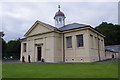
Library, RMA Sandhurst
Originally built as a gymnasium in 1863. Converted to a library in 1931.
See http://list.english-heritage.org.uk/resultsingle.aspx?uid=1390372
Image: © Ian Taylor
Taken: 15 Jun 2014
0.23 miles
4
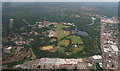
Sandhurst Royal Military Academy: aerial 2016
In the foreground is not the college building but a shopping centre.
Image: © Chris
Taken: 10 Jun 2016
0.25 miles