IMAGES TAKEN NEAR TO
Silverwood Drive, CAMBERLEY, GU15 2AT
Introduction
This page details the photographs taken nearby to Silverwood Drive, GU15 2AT by members of the Geograph project.
The Geograph project started in 2005 with the aim of publishing, organising and preserving representative images for every square kilometre of Great Britain, Ireland and the Isle of Man.

There are currently over 7.5m images from over14,400 individuals and you can help contribute to the project by visiting https://www.geograph.org.uk
Image Map
Images are licensed for reuse under creativecommons.org/licenses/by-sa/2.0
Notes
- Clicking on the map will re-center to the selected point.
- The higher the marker number, the further away the image location is from the centre of the postcode.
Image Listing (33 Images Found)
Images are licensed for reuse under creativecommons.org/licenses/by-sa/2.0
Image
Details
Distance
1
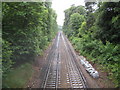
Camberley: Ascot to Guildford railway
The London & South Western Railway opened their route through here in 1878. This is the view looking towards Camberley from the Gibbet Lane bridge. The railway was unusually quiet, even for a Sunday, as trains were largely suspended in the area while Network Rail were trying to repair damage reputedly caused by an attempted cable theft in the Woking area on 9 June 2011.
Image: © Nigel Cox
Taken: 12 Jun 2011
0.06 miles
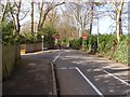
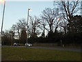
3
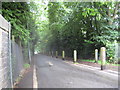
Camberley: Gibbet Lane
Massed ranks of wooden posts separate the one-way southbound road and the pedestrian and cycle way. This is the view from the railway bridge.
Image: © Nigel Cox
Taken: 12 Jun 2011
0.10 miles
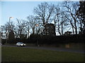
4
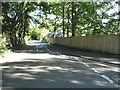
Crawley Ridge at the junction of Gibbet Lane
Image: © David Howard
Taken: 7 Jun 2015
0.11 miles
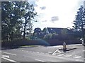
5
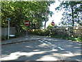
Gibbett Lane, Camberley
The junction of Gibbett Lane with Crawley Ridge on the left. After this point Gibbett lane becomes a narrow one way road running up towards the A30.
Image: © Alan Hunt
Taken: 17 Feb 2013
0.11 miles
6
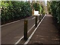
Gibbett Lane, Camberley
Gibbett Lane looking towards the railway bridge with the wooden bollards separating the cycle lane from the vehicle lane.
Image: © Alan Hunt
Taken: 17 Feb 2013
0.12 miles
8
Gibbet Lane at the junction of Portsmouth Road
Image: © David Howard
Taken: 7 Jun 2015
0.13 miles
10
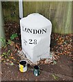
Old Milestone by the A30, London Road, Camberley
Carved stone post by the A30, in parish of Camberley (Surrey Heath District), by traffic lights at junction of London Road with Caesar's Camp Road, beyond roadside rails, on grass between path and wooden fence, on South South-east side of road. Hartford limestone diamond, erected by the Basingstoke, Hartfordbridge & Blackwater (and Odiham) Turnpike Trust in the 19th century.
Inscription reads:-
: Hartford Bridge / 7¾ : : LONDON / 28 : : Bagshot / 1¾ :
Carved benchmark on mid left.
Milestone Society National ID: SY_LE28.
Image: © Milestone Society
Taken: 15 Sep 2017
0.14 miles