IMAGES TAKEN NEAR TO
Foxhill Crescent, CAMBERLEY, GU15 1PR
Introduction
This page details the photographs taken nearby to Foxhill Crescent, GU15 1PR by members of the Geograph project.
The Geograph project started in 2005 with the aim of publishing, organising and preserving representative images for every square kilometre of Great Britain, Ireland and the Isle of Man.

There are currently over 7.5m images from over14,400 individuals and you can help contribute to the project by visiting https://www.geograph.org.uk
Image Map
Images are licensed for reuse under creativecommons.org/licenses/by-sa/2.0
Notes
- Clicking on the map will re-center to the selected point.
- The higher the marker number, the further away the image location is from the centre of the postcode.
Image Listing (16 Images Found)
Images are licensed for reuse under creativecommons.org/licenses/by-sa/2.0
Image
Details
Distance
1
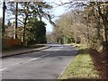
The Maultway
The Maultway from the entrance to the Black Hill car park. This link road runs from Deepcut to the Jolly Farmer roundabout on the A30.
Image: © Alan Hunt
Taken: 17 Feb 2013
0.09 miles
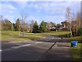
2
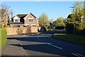
Seymour Drive, Camberley
A modern development on near the eastern edge of the town.
Image: © Andrew Smith
Taken: 18 Apr 2021
0.12 miles
3
Black Hill
The disused part of the MOD vehicle testing area north of the M3. This is still owned by the MOD but only has recreational use.
Image: © Alan Hunt
Taken: 17 Jul 2010
0.14 miles
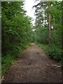
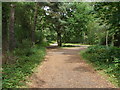
4
Footpath in woodland
This path runs parallel to The Maultway road.
Image: © don cload
Taken: 23 Feb 2010
0.14 miles
5
Seymour Drive, Camberley
A new housing estate built in the 1990s on the site of the WRAC college. Seymour drive was the access road to the college.
Image: © Alan Hunt
Taken: 17 Feb 2013
0.17 miles
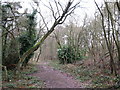
6
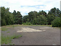
Black Hill
Old hardstanding of some long abandoned Army facility.
Image: © Alan Hunt
Taken: 17 Jul 2010
0.19 miles
7
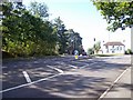
Jolly Farmer roundabout & Basing Stone
This is where the A30 separates into the Old Portsmouth Road, (left fork), and the A30 through Camberly (right fork). Situated on the roundabout is a golf pro shop which used to be the Jolly Farmer pub. Originally this was a posting inn situated at the top of the long drag up from Bagshot. The inn was originally called "The Golden Farmer" after a local farmer whose source of wealth was a mystery, until a highwayman was captured and found to be one and the same person ! The Basing Stone, which marks the parish boundary can be seen on the left hand side of the road.
Image: © Len Williams
Taken: 1 Sep 2009
0.20 miles
8
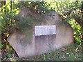
The Basing Stone
This stone is located on the A30 adjacent to the traffic lights at the Jolly Farmer roundabout. The very worn plaque reads "SITE OF BASING STONE AND LEGEND OF THE WHITE HART". The stone, (which replaces an earlier one that was destroyed in the 1950's), marks the parish boundary. The legend of the White Hart, as given by a booklet: Medieval Surrey Heath. 1996 PJ Stevens is :- "Legend says that near the Basingstone (Beausantstone) Richard II was attacked by a wounded stag while hunting. He was apparently saved by a White Hart that came between them. In gratitude the King is said to have caused four hostelries with the sign of the White Hart to be erected in the forest at Bagshot, Chobham, Frimley, and Pirbright."
Image: © Len Williams
Taken: 1 Sep 2009
0.20 miles
9
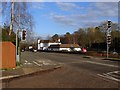
The Jolly Farmer roundabout
The former Jolly Farmer inn now converted to a golfing shop that occupies a site in the middle of the roundabout on the A30.
Image: © Alan Hunt
Taken: 17 Feb 2013
0.21 miles
10
Black Hill
The main track from the car park to the water tower, the most prominent feature on Black Hill.
Image: © Alan Hunt
Taken: 17 Jul 2010
0.22 miles