IMAGES TAKEN NEAR TO
Hammersley Drive, ALDERSHOT, GU12 6FT
Introduction
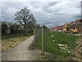
This page details the photographs taken nearby to Hammersley Drive, GU12 6FT by members of the Geograph project.
The Geograph project started in 2005 with the aim of publishing, organising and preserving representative images for every square kilometre of Great Britain, Ireland and the Isle of Man.

There are currently over 7.5m images from over14,400 individuals and you can help contribute to the project by visiting https://www.geograph.org.uk
Image Map
Images are licensed for reuse under creativecommons.org/licenses/by-sa/2.0
Notes
- Clicking on the map will re-center to the selected point.
- The higher the marker number, the further away the image location is from the centre of the postcode.
Image Listing (50 Images Found)
Images are licensed for reuse under creativecommons.org/licenses/by-sa/2.0
Image
Details
Distance
1
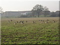
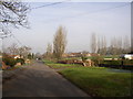
Geese in a field, Ash, Surrey
There are many areas of open water in the Blackwater Valley, and these attract geese (I'm not expert enough to know what species), which can evidently find food in a winter field. Ash Manor Secondary School is in the background. Telephoto used for obvious reasons (especially as I had a dog with me!).
Image: © Humphrey Bolton
Taken: 24 Jan 2006
0.10 miles
2
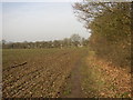
Field path, Ash, Surrey
Looking northwards towards Ash Street (The A323). Suburbia can be glimpsed in the distance.
Image: © Humphrey Bolton
Taken: 24 Jan 2006
0.11 miles
3
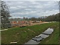
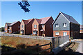
Building on greenbelt
Early days of the Bewley Homes development marketed as "Ash Lodge Park". These homes will be in a road named Little Hannocks Close.
Image: © Fernweh
Taken: 8 Apr 2021
0.17 miles
4
More New Housing
Land north of the old railway path is all being built on.
Image: © Des Blenkinsopp
Taken: 10 Aug 2022
0.17 miles
5
Plot 165 - The Datchet
Early days of the Bewley Homes development marketed as "Ash Lodge Park". This house was on the market for over £400,000. The road will be known as Minleys Close.
Image: © Fernweh
Taken: 8 Apr 2021
0.17 miles
6
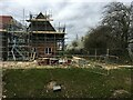
Building on greenbelt
Early days of the Bewley Homes development marketed as "Ash Lodge Park". The houses still with scaffolding are marketed as "The Curridge", 4-bedroom detached family homes, (plots 167-169). At the time this photo was taken they were priced at £650,000.
Image: © Fernweh
Taken: 8 Apr 2021
0.17 miles
7
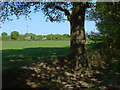
Fields near Ash
A view of the fields to the north of Ash Green Lane West.
Image: © Alan Hunt
Taken: 25 Apr 2011
0.17 miles
8
South Lane, Ash, Surrey
What was a narrow unsurfaced lane is now a residential road, although there is still a field or two to develop.
Image: © Humphrey Bolton
Taken: 24 Jan 2006
0.17 miles
9
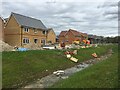
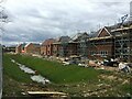
New builds on greenbelt
The nearest house is being marketed as "The Sonning" - plot 162, £625,000. A 4-bedroom detached homes on the edge of the development which will benefit from a woodland view out front. The house with the slightly darker bricks is also known as "The Sonning", plot 170.
Their address will be Minleys Close.
Image: © Fernweh
Taken: 8 Apr 2021
0.18 miles