IMAGES TAKEN NEAR TO
Hop Garden Way, ALDERSHOT, GU12 6FN
Introduction
This page details the photographs taken nearby to Hop Garden Way, GU12 6FN by members of the Geograph project.
The Geograph project started in 2005 with the aim of publishing, organising and preserving representative images for every square kilometre of Great Britain, Ireland and the Isle of Man.

There are currently over 7.5m images from over14,400 individuals and you can help contribute to the project by visiting https://www.geograph.org.uk
Image Map (Loading...)


Getting Data...Please wait
Leaflet Map data © OpenStreetMap
Images are licensed for reuse under creativecommons.org/licenses/by-sa/2.0
Notes
- Clicking on the map will re-center to the selected point.
- The higher the marker number, the further away the image location is from the centre of the postcode.
Image Listing (85 Images Found)
Images are licensed for reuse under creativecommons.org/licenses/by-sa/2.0
Image
Details
Distance
1
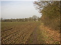
Field path, Ash, Surrey
Looking northwards towards Ash Street (The A323). Suburbia can be glimpsed in the distance.
Image: © Humphrey Bolton
Taken: 24 Jan 2006
0.02 miles
2
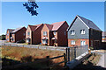
More New Housing
Land north of the old railway path is all being built on.
Image: © Des Blenkinsopp
Taken: 10 Aug 2022
0.05 miles
3
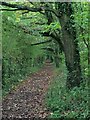
Attractive path running alongside dismantled railway
Image: © don cload
Taken: 18 Oct 2013
0.06 miles
4
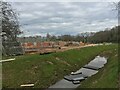
Building on greenbelt
Early days of the Bewley Homes development marketed as "Ash Lodge Park". These homes will be in a road named Little Hannocks Close.
Image: © Fernweh
Taken: 8 Apr 2021
0.07 miles
5
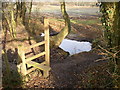
Stile and pond, Ash, Surrey
The stile hardly seems necessary, as you can walk round it; however it does lead to a plank over the mud. The footpath leads up to Ash Street, opposite Star Lane. The pond is where a ditch discharges into a culvert under a byway and disused railway.
Image: © Humphrey Bolton
Taken: 24 Jan 2006
0.07 miles
6
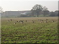
Geese in a field, Ash, Surrey
There are many areas of open water in the Blackwater Valley, and these attract geese (I'm not expert enough to know what species), which can evidently find food in a winter field. Ash Manor Secondary School is in the background. Telephoto used for obvious reasons (especially as I had a dog with me!).
Image: © Humphrey Bolton
Taken: 24 Jan 2006
0.08 miles
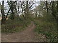
8

Dismantled railway looking towards Tongham
This is now a recreational route. See Image
A view from the opposite direction is at http://www.geograph.org.uk/photo/2381265.
Image: © Shazz
Taken: 21 Jun 2014
0.09 miles
9
Plot 165 - The Datchet
Early days of the Bewley Homes development marketed as "Ash Lodge Park". This house was on the market for over £400,000. The road will be known as Minleys Close.
Image: © Fernweh
Taken: 8 Apr 2021
0.09 miles
10
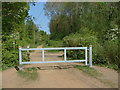
Ash, disused railway
A barrier across the disused railway now used as a bridleway. On the left is the corner of Bin Wood.
Image: © Alan Hunt
Taken: 25 Apr 2011
0.10 miles