IMAGES TAKEN NEAR TO
Frampton Mansell, STROUD, GL6 8JQ
Introduction
This page details the photographs taken nearby to GL6 8JQ by members of the Geograph project.
The Geograph project started in 2005 with the aim of publishing, organising and preserving representative images for every square kilometre of Great Britain, Ireland and the Isle of Man.

There are currently over 7.5m images from over14,400 individuals and you can help contribute to the project by visiting https://www.geograph.org.uk
Image Map
Images are licensed for reuse under creativecommons.org/licenses/by-sa/2.0
Notes
- Clicking on the map will re-center to the selected point.
- The higher the marker number, the further away the image location is from the centre of the postcode.
Image Listing (60 Images Found)
Images are licensed for reuse under creativecommons.org/licenses/by-sa/2.0
Image
Details
Distance
1
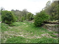
Trackway and canal in the Golden Valley
Viewed from the railway line. Tanner's Wood seen in background.
Image: © Clint Mann
Taken: 2 Oct 2015
0.03 miles
2
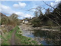
Old lock-keepers cottage
Beside the disused Thames & Severn Canal near Frampton Mansell village.
Image: © Jeremy Bolwell
Taken: 28 Mar 2010
0.04 miles
3
Buried stone
Buried stone in correct location for unrecorded milestone. Inscription would read Wallbridge...6, Inglesham...22 3/4
Image: © James Clarke
Taken: 26 Dec 2021
0.04 miles
4
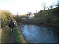
Puck Mill Upper Lock
This lock on the Thames & Severn Canal is to the left of the unusual lock keeper's cottage and has an aqueduct underneath over the River Frome. The pound visible in the picture between the two Puck Mill Locks was completely relined with clay in the early 1900s but today it leaks like a sieve and only holds water after exceptionally wet periods. No prizes for guessing what the weather had been like in the days just before this picture was taken!
Image: © David Stowell
Taken: 30 Jan 2008
0.08 miles
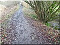
5
The bed of the former Thames and Severn Canal
We were walking west on the south bank, and at this point just carried on doing so. Fortunately, within a few yards I realised that we should have crossed to the north bank (and the clear path seen here on the right). Even more fortunately, my shouts to my companions (who were ahead) alerted another couple to the fact that they had made the same error.
When I did the walk (April 2017) there was no waymarking at this spot indicating the need to change banks (though there was for those walking east). I hope that this will have been corrected by the time you arrive.
Image: © David Purchase
Taken: 20 Apr 2017
0.10 miles
6
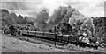
A 'Castle' struggles towards Sapperton Tunnel with an Up Parcels
View SW, down the Golden Valley towards Stroud and Gloucester; ex-GWR Swindon - Gloucester main line. No. 4085 'Berkeley Castle, now (in 1961) not feeling very well and has been demoted by Diesels from the express duties it had served for most of its previous 35 years; it survived until 5/62. It is at Frampton Crossing about half way up the gruelling climb from Brimscombe to Sapperton Tunnel.
Image: © Ben Brooksbank
Taken: 29 Jul 1961
0.11 miles
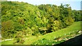
9
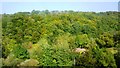
Woodland north of railway line
Dense woodland adorns the hills to the north of the Severn and Thames Canal. Bristley Hill Wood and (to the right) Tanner's Wood are located here.
Image: © Clint Mann
Taken: 2 Oct 2015
0.14 miles
10
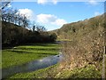
Flooded River Frome
Seen from the adjacent Thames & Severn Canal above Whitehall Lock. Although blue skies are in evidence the preceding period had been rather wet!
Image: © David Stowell
Taken: 30 Jan 2008
0.15 miles