IMAGES TAKEN NEAR TO
The Vatch, STROUD, GL6 7LE
Introduction
This page details the photographs taken nearby to The Vatch, GL6 7LE by members of the Geograph project.
The Geograph project started in 2005 with the aim of publishing, organising and preserving representative images for every square kilometre of Great Britain, Ireland and the Isle of Man.

There are currently over 7.5m images from over14,400 individuals and you can help contribute to the project by visiting https://www.geograph.org.uk
Image Map
Images are licensed for reuse under creativecommons.org/licenses/by-sa/2.0
Notes
- Clicking on the map will re-center to the selected point.
- The higher the marker number, the further away the image location is from the centre of the postcode.
Image Listing (12 Images Found)
Images are licensed for reuse under creativecommons.org/licenses/by-sa/2.0
Image
Details
Distance
1
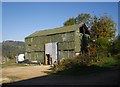
Barn at Stroud Slad Farm
Quite an impressive corrugated iron structure, seen from Slad Lane. The sign on the door directs one to the toilets, incidentally.
Image: © Derek Harper
Taken: 19 Oct 2007
0.01 miles
2
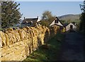
Stroud Slad Farm
An ambitious organic farm on the side of the Slad valley. The golden limestone wall beside Slad Lane looks a recent addition.
Image: © Derek Harper
Taken: 19 Oct 2007
0.06 miles
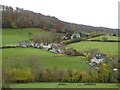
3
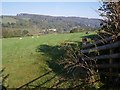
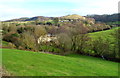
Slad valley from Slad Lane
Slad Lane runs along the southeastern slopes of the valley from Stroud to The Vatch; here it is rounding a spur as it approaches Stroud Slad Farm. The buildings are around the area where the lane crosses the valley to meet Slad Road, which runs along the far side. The most prominent, Gravel Hill, is actually in SO8606.
Image: © Derek Harper
Taken: 19 Oct 2007
0.08 miles
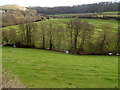
4
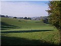
Field beside Slad Lane
Only the nearer part of this field, crossed by a combe in the side of the Slad valley, is in square. In the distance is All Saints church in Uplands, Stroud.
Image: © Derek Harper
Taken: 19 Oct 2007
0.17 miles
5
Slad Brook viewed from the B4070
Looking down Slad Valley towards Slad Brook.
Image: © Jaggery
Taken: 8 Jan 2012
0.18 miles
6
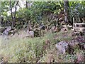
Quarry near Worgan's Wood
These tumbled stones are what remains of one of the many disused quarries that dot the Cotswolds. All that honey-coloured masonry has to come from somewhere.
Image: © Mike White
Taken: 10 Sep 2008
0.21 miles
7
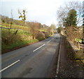
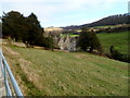
The B4070 between Stroud and Slad
Looking NE along the B4070 in the direction of the Cotswolds village of Slad.
The perimeter wall of The Reddings is on the right. Hazeling is on the left.
Image: © Jaggery
Taken: 8 Jan 2012
0.22 miles
8
The Vatch
The Vatch in the Slad valley.
Image: © Philip Halling
Taken: 19 Nov 2016
0.22 miles
9
Spring Cottages, The Vatch near Slad
A view NE from the B4070 down Slad Valley looking beyond trees towards Spring Cottages, alongside Slad Brook.
Image: © Jaggery
Taken: 8 Jan 2012
0.23 miles
10
Hazel Mill, Vatch, Stroud
Viewed from railings alongside Slad Road. The house is at the edge of Slad Brook.
Image: © Jaggery
Taken: 8 Jan 2012
0.24 miles