IMAGES TAKEN NEAR TO
Vicarage Street, STROUD, GL6 6XR
Introduction
This page details the photographs taken nearby to Vicarage Street, GL6 6XR by members of the Geograph project.
The Geograph project started in 2005 with the aim of publishing, organising and preserving representative images for every square kilometre of Great Britain, Ireland and the Isle of Man.

There are currently over 7.5m images from over14,400 individuals and you can help contribute to the project by visiting https://www.geograph.org.uk
Image Map (125 Images)


Leaflet Map data © OpenStreetMap
Images are licensed for reuse under creativecommons.org/licenses/by-sa/2.0
Notes
- Clicking on the map will re-center to the selected point.
- The higher the marker number, the further away the image location is from the centre of the postcode.
Image Listing (125 Images Found)
Images are licensed for reuse under creativecommons.org/licenses/by-sa/2.0
Image
Details
Distance
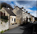
1
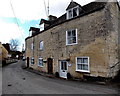
Rock Cottages, Painswick
Row of 3 cottages near the NE edge of Painswick.
Image: © Jaggery
Taken: 23 Mar 2014
0.01 miles
2
Dozmary Cottage, Painswick
Formerly known as Ivy Cottage and now much altered from the original, Dozmary Cottage
shows the year 1785 on a panel above the topmost window. Grade II listed in 1990.
Image: © Jaggery
Taken: 23 Mar 2014
0.03 miles
3
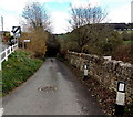
Towards Sheepscombe along Vicarage Street, Painswick
At the Lower Washwell Lane junction, a sign on the bank points east along Vicarage Lane towards Sheepscombe.
Image: © Jaggery
Taken: 23 Mar 2014
0.03 miles
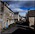
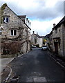
4
West along Vicarage Street, Painswick
Looking towards the town centre from the Lower Washwell Lane junction.
Image: © Jaggery
Taken: 23 Mar 2014
0.05 miles
5
Glendale Cottage, Painswick
Viewed across Vicarage Street.
Image: © Jaggery
Taken: 23 Mar 2014
0.05 miles
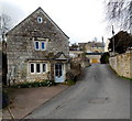
6
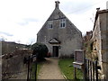
Quaker Meeting House, Painswick
Set back 25 metres from the south side of Vicarage Street. The information board on the right states that the Meeting House dates from 1706, 50 years after Quakers came to Painswick. Quaker worship is based on silence. This is reflected in the simplicity of the building, which is furnished with simple deal benches. An upper room has been used as a school room.
Image: © Jaggery
Taken: 23 Mar 2014
0.06 miles
7
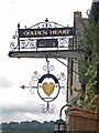
The Golden Heart Tea House sign
What a lovely pub sign, I thought, 'Golden Heart Free House'. It's slightly clearer on the other side, though.
Image: © Mike White
Taken: 10 Sep 2008
0.07 miles
8
Milton Cottage, Painswick
On the left side of Vicarage Street, the house with the blue front door is Milton Cottage.
Image: © Jaggery
Taken: 23 Mar 2014
0.08 miles
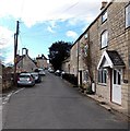
9
Vicarage Street, Painswick
Looking east, away from the town centre.
Image: © Jaggery
Taken: 23 Mar 2014
0.12 miles
10
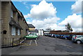
The Painswick Centre car park
Viewed from Bisley Street, Painswick. The main community centre building is on the left.
Outdoor facilities out of shot ahead include a bowling green, tennis court and large grass recreation area.
Image: © Jaggery
Taken: 23 Mar 2014
0.14 miles