IMAGES TAKEN NEAR TO
Bread Street, STROUD, GL6 6EJ
Introduction
This page details the photographs taken nearby to Bread Street, GL6 6EJ by members of the Geograph project.
The Geograph project started in 2005 with the aim of publishing, organising and preserving representative images for every square kilometre of Great Britain, Ireland and the Isle of Man.

There are currently over 7.5m images from over14,400 individuals and you can help contribute to the project by visiting https://www.geograph.org.uk
Image Map
Images are licensed for reuse under creativecommons.org/licenses/by-sa/2.0
Notes
- Clicking on the map will re-center to the selected point.
- The higher the marker number, the further away the image location is from the centre of the postcode.
Image Listing (9 Images Found)
Images are licensed for reuse under creativecommons.org/licenses/by-sa/2.0
Image
Details
Distance
1
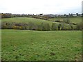
View across Ruscombe
View across Ruscombe to Whiteshill.
Image: © Philip Halling
Taken: 19 Nov 2016
0.11 miles
2
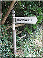
Fingerpost, Ruscombe, Stroud
On the Ruscombe Road, opposite "the Lane", which ends up in Randwick village. The finger is modern but the post is traditional with castellated sleeves and even the truncated finger of the original, albeit pointing into the hedge.
Inscription: Randwick
Milestone Society National ID: GL_SO8306
Image: © Mr Red
Taken: 15 Jul 2022
0.14 miles
3
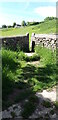
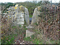
Stone Stile Ruscombe Farm GS9316
Stone squeeze stile, Ruscombe. Fairly modern looking squeeze in stone wall, at side of field adjacent to Ruscombe Farm, leads onto path by pond. On public right of way MWH17. See also https://www.geograph.org.uk/photo/7184924
Image: © Bill Mesley
Taken: 27 May 2022
0.16 miles
4
Stone Stile Ruscombe Farm GS9316
Stone squeeze/gap stile, Ruscombe. Fairly modern looking squeeze or gap in stone wall, at side of field adjacent to Ruscombe Farm, leads onto path by pond. On public right of way MWH17. See also https://www.geograph.org.uk/photo/7184620
Image: © Bill Mesley
Taken: 27 May 2022
0.17 miles
5
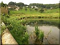
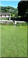
Pond, Ruscombe
The path from Whiteshill to Ruscombe Farm crosses a valley and passes this pond at the bottom of it. The farm is ahead on the left.
Image: © Derek Harper
Taken: 18 Sep 2008
0.19 miles
6
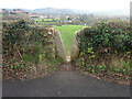
Stone Stile Ruscombe Rd
In the area known as Bread Street nr Ruscombe. The view from the field is Image
Image: © Mr Red
Taken: 30 Nov 2021
0.20 miles
7
Stone Stile Ruscombe Rd
In the area known as Bread Street nr Ruscombe. The view from the field is Image
Image: © Mr Red
Taken: 30 Nov 2021
0.20 miles
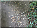
8
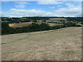
The valley of Ruscombe Brook
In the Cotswolds AONB, just north of Stroud.
Image: © Christine Johnstone
Taken: 15 Jul 2022
0.22 miles
9
Stone Stile, Randwick
Where Gloucestershire bridleway MRA32 ends at Ruscombe Road. These features often divert rain to one side, but the path is so dished, this could not be the purpose. It had to have been a stile. The bridleway also marks the boundary of Whiteshill and Randwick parishes.
Image: © Mr Red
Taken: 15 Jul 2022
0.23 miles