IMAGES TAKEN NEAR TO
Main Road, STROUD, GL6 6AX
Introduction
This page details the photographs taken nearby to Main Road, GL6 6AX by members of the Geograph project.
The Geograph project started in 2005 with the aim of publishing, organising and preserving representative images for every square kilometre of Great Britain, Ireland and the Isle of Man.

There are currently over 7.5m images from over14,400 individuals and you can help contribute to the project by visiting https://www.geograph.org.uk
Image Map
Images are licensed for reuse under creativecommons.org/licenses/by-sa/2.0
Notes
- Clicking on the map will re-center to the selected point.
- The higher the marker number, the further away the image location is from the centre of the postcode.
Image Listing (44 Images Found)
Images are licensed for reuse under creativecommons.org/licenses/by-sa/2.0
Image
Details
Distance
1
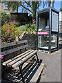
Reading in Whiteshill
A familiar sight these days: a telephone box is now a local library. The seat, handily placed, bears a memorial to a local woman.
Image: © Neil Owen
Taken: 8 Jun 2023
0.02 miles
2
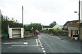
Bus shelter on Main Road, Whiteshill
This is at the junction with Victory Road.
Image: © Humphrey Bolton
Taken: 11 Jul 2017
0.06 miles
3
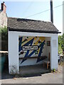
Main Road bus shelter in Whiteshill
There is a certain celebration of a humble bus shelter in the village. See Image] for a look at more inside.
Image: © Neil Owen
Taken: 8 Jun 2023
0.07 miles
4
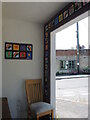
Tiles in the shelter
The interior of the open bus shelter has some unexpected and colourful decorations. A domestic chair adds to the homely feel. See Image] for an exterior view.
Image: © Neil Owen
Taken: 8 Jun 2023
0.07 miles
5
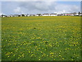
Whiteshill village
Whiteshill village is 2Km north of Stroud. The Cotswold Way path is 1Km to the west in Standish woods.
Image: © Vincent Jones
Taken: 29 Apr 2006
0.08 miles
6
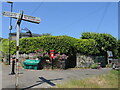
No through road to the Kitesnest
A junction in Whiteshill, with a few municipal street ingredients. The gardens beyond were part of a pub that has now closed.
Image: © Neil Owen
Taken: 8 Jun 2023
0.10 miles
7
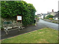
Seat on a corner at Whiteshill
This is at the junction of main Road and Upper Kitesnest Lane.
Image: © Humphrey Bolton
Taken: 11 Jul 2017
0.10 miles
8
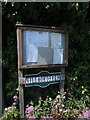
News on Upper Kitesnest Lane
Village news and communications in Whiteshill.
Image: © Neil Owen
Taken: 8 Jun 2023
0.10 miles
9
Woodcutters Arms, Whiteshill
The pub occupies the fork of land between Upper Kitesnest Road and the Main Road in this ridge village.
Image: © Derek Harper
Taken: 5 Jul 2006
0.12 miles
10
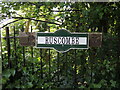
Sign for Ruscombe
An unusual style of sign for the village entrance on Ruscombe Road, with reference to the Queen's Golden Jubilee of 2002. It is accompanied by a cast plate of lesser conspicuity that also marks that year's celebrations.
Image: © Neil Owen
Taken: 8 Jun 2023
0.13 miles