IMAGES TAKEN NEAR TO
Old Bristol Road, STROUD, GL6 0JP
Introduction
This page details the photographs taken nearby to Old Bristol Road, GL6 0JP by members of the Geograph project.
The Geograph project started in 2005 with the aim of publishing, organising and preserving representative images for every square kilometre of Great Britain, Ireland and the Isle of Man.

There are currently over 7.5m images from over14,400 individuals and you can help contribute to the project by visiting https://www.geograph.org.uk
Image Map
Images are licensed for reuse under creativecommons.org/licenses/by-sa/2.0
Notes
- Clicking on the map will re-center to the selected point.
- The higher the marker number, the further away the image location is from the centre of the postcode.
Image Listing (131 Images Found)
Images are licensed for reuse under creativecommons.org/licenses/by-sa/2.0
Image
Details
Distance
1
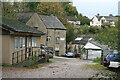
Gigg Mill, Nailsworth
This unprepossessing, rendered L-shaped building (just left of centre) with an attached small north-light shed has a long history. The site dates back to at least 1559 when Gigg Mill was granted to a local clothier. In 1786 the mill was being operated as both a grist and fulling mill with separate tenants. In 1850 the sale notice listed two waterwheels, two pairs of stocks (fulling stocks), gig, drums etc. In 1856 it was making flock and shoddy (waste textile products) and in 1862 the roof was destroyed by fire. In the early 20th century it was a fellmongers dealing with animal carcasses. It is now used in engineering and part of the site has a display of textile machinery demonstrated by the Stroudwater Textile Trust.
Image: © Chris Allen
Taken: 27 Oct 2013
0.01 miles
2
Gigg Mill, Nailsworth
This unprepossessing, rendered L-shaped building (part seen on the left) with an attached small north-light shed has a long history. The site dates back to at least 1559 when Gigg Mill was granted to a local clothier. In 1786 the mill was being operated as both a grist and fulling mill with separate tenants. In 1850 the sale notice listed two waterwheels, two pairs of stocks (fulling stocks), gig, drums etc. In 1856 it was making flock and shoddy (waste textile products) and in 1862 the roof was destroyed by fire. In the early 20th century it was a fellmongers dealing with animal carcasses. It is now used in engineering and part of the site has a display of textile machinery demonstrated by the Stroudwater Textile Trust.
Image: © Chris Allen
Taken: 27 Oct 2013
0.01 miles
3
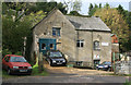
Gigg Mill, Nailsworth
This unprepossessing, rendered L-shaped building with an attached small north-light shed has a long history. The site dates back to at least 1559 when Gigg Mill was granted to a local clothier. In 1786 the mill was being operated as both a grist and fulling mill with separate tenants. In 1850 the sale notice listed two waterwheels, two pairs of stocks (fulling stocks), gig, drums etc. In 1856 it was making flock and shoddy (waste textile products) and in 1862 the roof was destroyed by fire. In the early 20th century it was a fellmongers dealing with animal carcasses. It is now used in engineering and part of the site has a display of textile machinery demonstrated by the Stroudwater Textile Trust.
Image: © Chris Allen
Taken: 27 Oct 2013
0.01 miles
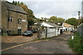
4
Gigg Mill, Nailsworth.
This is the building in the background with what appears to be an asbestos cement roof.
This unprepossessing, rendered L-shaped building with an attached small north-light shed has a long history. The site dates back to at least 1559 when Gigg Mill was granted to a local clothier. In 1786 the mill was being operated as both a grist and fulling mill with separate tenants. In 1850 the sale notice listed two waterwheels, two pairs of stocks (fulling stocks), gig, drums etc. In 1856 it was making flock and shoddy (waste textile products) and in 1862 the roof was destroyed by fire. In the early 20th century it was a fellmongers dealing with animal carcasses. It is now used in engineering and part of the site has a display of textile machinery demonstrated by the Stroudwater Textile Trust.
In the foreground is a Severn Trent pumping station.
Image: © Chris Allen
Taken: 27 Oct 2013
0.02 miles
5
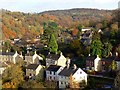
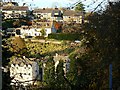
Another view of Nailsworth
The town is relatively isolated in its niche in the Cotswolds. The hilly terrain hereabouts made it relatively difficult to reach. There is more on the history of Nailsworth on its unofficial website http://www.nailsworth.com/
Image: © Brian Robert Marshall
Taken: 11 Nov 2008
0.03 miles
6
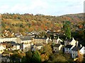
A view of Nailsworth
The viewpoint is Rockness Hill, facing east across the valley in which the town is situated. The town is typically Cotswolds but has yet to find its way onto the list of main tourist destinations. The first settlement hereabouts seems to have taken place in the 12th century http://www.nailsworth-gloucestershire.com/nailsworth-history.htm
Image: © Brian Robert Marshall
Taken: 11 Nov 2008
0.04 miles
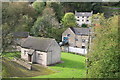
7
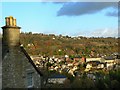
Nailsworth from Rockness
The centre of the town is seen from near Rockness House (the property at the left), which occupies a position on the western side of the valley in which the town is situated.
Image: © Brian Robert Marshall
Taken: 11 Nov 2008
0.04 miles
8
ex Toll House, Horsley Road, Nailsworth
At the junction of Pike Lane with Horsley Road, which was a turnpike from Nailsworth to Wotton under Edge and Dursley. This section of Horsley Road to the junction with the Old Bristol Road was superseded but the then "new" Old Bristol Road when it was made in 1822. There is a Toll House further West of that junction which would have served from that time on. Served the Coldharbour Turnpike Trust.
https://www.geograph.org.uk/photo/7435525
Milestone Society National ID: GL.NAI04
Image: © Mr Red
Taken: 22 Nov 2022
0.04 miles
9
Worley, Nailsworth
Nailsworth lies at the confluence of several valleys. This view is across the valley leading in from the west. The houses on the far side probably date from the 1960s or 70s.
Image: © Brian Robert Marshall
Taken: 11 Nov 2008
0.09 miles
10
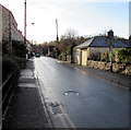
Old Bristol Road, Nailsworth
The B4058 Old Bristol Road viewed from near the A46 Bath Road junction.
Double yellow lines on both sides indicate no parking at any time.
Image: © Jaggery
Taken: 20 Dec 2015
0.11 miles