IMAGES TAKEN NEAR TO
MORETON-IN-MARSH, GL56 9TR
Introduction
This page details the photographs taken nearby to GL56 9TR by members of the Geograph project.
The Geograph project started in 2005 with the aim of publishing, organising and preserving representative images for every square kilometre of Great Britain, Ireland and the Isle of Man.

There are currently over 7.5m images from over14,400 individuals and you can help contribute to the project by visiting https://www.geograph.org.uk
Image Map
Images are licensed for reuse under creativecommons.org/licenses/by-sa/2.0
Notes
- Clicking on the map will re-center to the selected point.
- The higher the marker number, the further away the image location is from the centre of the postcode.
Image Listing (19 Images Found)
Images are licensed for reuse under creativecommons.org/licenses/by-sa/2.0
Image
Details
Distance
1
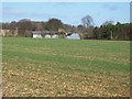
Upton Wold Farm
Seen from the bridleway.
Image: © Michael Dibb
Taken: 26 Nov 2009
0.00 miles
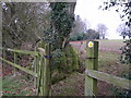
2
Upton Wold Farm
This view is from the footpath that runs to the rear of the farm. Until recently, the footpath ran through the farm but it has been diverted by statutory order.
Image: © Michael Dibb
Taken: 12 Nov 2009
0.04 miles
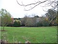
3
Ha-ha below Upton Wold
Ha-ha dividing garden from field without interrupting the view.
Image: © Liz Stone
Taken: 29 Jan 2011
0.09 miles
4
![A circular walk around Blockley [11]](https://s2.geograph.org.uk/geophotos/07/03/90/7039074_043e9ff5_120x120.jpg)
A circular walk around Blockley [11]
The driveway to Upton Wold Farm with some fine gate piers.
The route follows Five Mile Drive through Bourton Woods to the A44 road which is followed for a short distance. After leaving the road the route passes through Upton Wold on its way to Northwick Hill and Norcombe Wood. The return to Blockley is by way of Shales Coppice and The Warren. About 4½ miles.
Image: © Michael Dibb
Taken: 21 Jul 2021
0.10 miles
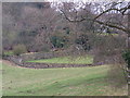
5
Beech by path
Field edge path with several old beech trees,also shows old stone gate post and freshly turned Cotswold soil.
Image: © Liz Stone
Taken: 29 Jan 2011
0.12 miles
6
Swollen tree bole
Very cankerous base of tree,near footpath gate at Upton Wold Farm.
Image: © Liz Stone
Taken: 29 Jan 2011
0.13 miles
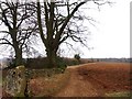
7
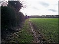
Field edge path
The footpath has a junction with a bridleway just north of Upton Wold Farm. This is a view of the bridleway as it heads south towards the A44. The line of the road is marked by the line of trees in the distance.
Image: © Michael Dibb
Taken: 26 Nov 2009
0.14 miles
8
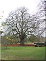
Lots of leaves
This handsome tree is just inside the gates of Upton Wold Farm. The tractor and trailer are there to collect the leaves - could be a long job.
Image: © Michael Dibb
Taken: 12 Nov 2009
0.15 miles
9
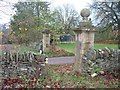
Paths meet at the gate
One footpath comes from the right, on this side of the wall and continues to the left on the driveway. The other footpath goes straight on. The gates are to Upton Wold Farm.
Image: © Michael Dibb
Taken: 12 Nov 2009
0.16 miles
10
![A circular walk around Blockley [12]](https://s3.geograph.org.uk/geophotos/07/03/90/7039075_2ac05e12_120x120.jpg)
A circular walk around Blockley [12]
The bridleway continues towards Northwick Hill.
The route follows Five Mile Drive through Bourton Woods to the A44 road which is followed for a short distance. After leaving the road the route passes through Upton Wold on its way to Northwick Hill and Norcombe Wood. The return to Blockley is by way of Shales Coppice and The Warren. About 4½ miles.
Image: © Michael Dibb
Taken: 21 Jul 2021
0.16 miles