IMAGES TAKEN NEAR TO
Aston Magna, MORETON-IN-MARSH, GL56 9QW
Introduction
This page details the photographs taken nearby to GL56 9QW by members of the Geograph project.
The Geograph project started in 2005 with the aim of publishing, organising and preserving representative images for every square kilometre of Great Britain, Ireland and the Isle of Man.

There are currently over 7.5m images from over14,400 individuals and you can help contribute to the project by visiting https://www.geograph.org.uk
Image Map
Images are licensed for reuse under creativecommons.org/licenses/by-sa/2.0
Notes
- Clicking on the map will re-center to the selected point.
- The higher the marker number, the further away the image location is from the centre of the postcode.
Image Listing (16 Images Found)
Images are licensed for reuse under creativecommons.org/licenses/by-sa/2.0
Image
Details
Distance
1
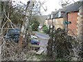
Path meets road
Near Corn Close Cottage, a path from Draycott meets the minor road from Paxford to Aston Magna.
Image: © Michael Dibb
Taken: 13 Feb 2010
0.02 miles
2
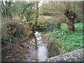
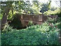
Waters meet
This view is from the bridge on the minor road from Paxford to Aston Magna. Blockley Brook comes from the left and flows into Knee Brook. Knee Brook eventually flows into the River Stour near Burmington.
Image: © Michael Dibb
Taken: 11 Nov 2009
0.04 miles
3
Diamond Way
Diamond Way heading over the Knee Brook Bridge
Image: © Shaun Ferguson
Taken: 14 Feb 2020
0.04 miles
4
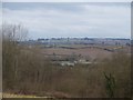
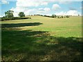
Gloucestershire farmland
The view from the minor road from Draycott to Aston Magna is far reaching. Ebrington Hill is seen in the distance.
Image: © Michael Dibb
Taken: 13 Feb 2010
0.04 miles
5
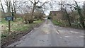
Road bridge over Knee Brook
Near Bran Mill.
Image: © Jennifer Luther Thomas
Taken: 23 Sep 2006
0.05 miles
6
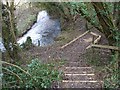
Alongside the stream
The footpath twists and turns as it makes its way through the trees alongside Blockley Brook. Much effort has been expended to make the path safer.
Image: © Michael Dibb
Taken: 13 Feb 2010
0.07 miles
7
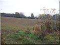
Where is the path?
From a bend in the minor road from Paxford to Aston Magna, a footpath crosses this field towards the gap in the hedge on the far side. The field has been ploughed and planted but the path has not been re-instated.
Image: © Michael Dibb
Taken: 11 Nov 2009
0.12 miles
8
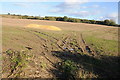
Footpath near Paxford
Footpath across a stubble field to the east of Paxford.
Image: © Philip Halling
Taken: 3 Nov 2013
0.12 miles
9
Looking North near bridge over Knee Brook
View of fields. The minor road, which goes over the bridge, is behind the hedge on the left.
Image: © Jennifer Luther Thomas
Taken: 23 Sep 2006
0.13 miles
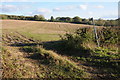
10
Arable land near Paxford
Arable land to the east of Paxford.
Image: © Philip Halling
Taken: 3 Nov 2013
0.14 miles