IMAGES TAKEN NEAR TO
Gloucester Lane, CHIPPING CAMPDEN, GL55 6RP
Introduction
This page details the photographs taken nearby to Gloucester Lane, GL55 6RP by members of the Geograph project.
The Geograph project started in 2005 with the aim of publishing, organising and preserving representative images for every square kilometre of Great Britain, Ireland and the Isle of Man.

There are currently over 7.5m images from over14,400 individuals and you can help contribute to the project by visiting https://www.geograph.org.uk
Image Map
Images are licensed for reuse under creativecommons.org/licenses/by-sa/2.0
Notes
- Clicking on the map will re-center to the selected point.
- The higher the marker number, the further away the image location is from the centre of the postcode.
Image Listing (58 Images Found)
Images are licensed for reuse under creativecommons.org/licenses/by-sa/2.0
Image
Details
Distance
1
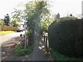
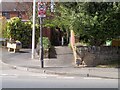
Towards High Street
This short footpath starts here in Chapel Lane and runs to High Street.
Image: © Michael Dibb
Taken: 10 Apr 2011
0.04 miles
2
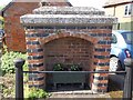
Former village tap
The housing for the tap and the balustrade are listed Grade II. There were originally three sources of piped water. Another housing survives in High Street.
Image: © Michael Dibb
Taken: 10 Apr 2011
0.05 miles
3
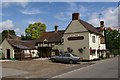
The Butcher's Arms
A traditional pub in Mickleton.
Image: © Colin Craig
Taken: 2 Aug 2009
0.08 miles
4
The Butchers Arms, Mickleton
Has a skittle alley
Image: © Tim Heaton
Taken: 25 Sep 2017
0.08 miles
5
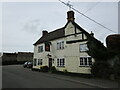
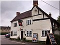
The Butcher's Arms, Micketon
The part of the builfdng closest to the camera dates from the seventeenth century https://historicengland.org.uk/listing/the-list/list-entry/1305756?section=official-list-entry
Image: © Jonathan Thacker
Taken: 22 Mar 2023
0.08 miles
6
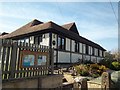
King George's Hall
Located in Chapel Lane, an extensive range of events are held in the hall.
Image: © Michael Dibb
Taken: 10 Apr 2011
0.08 miles
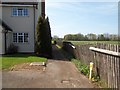
8
Path to Chapel Lane
From High Street, this footpath leads to Chapel Lane.
Image: © Michael Dibb
Taken: 10 Apr 2011
0.09 miles
9
Start of path
The footpath to Thistley Hill starts here where it leaves the street named Cotswold Edge.
Image: © Michael Dibb
Taken: 10 Apr 2011
0.09 miles
10
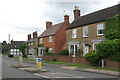
High Street, Mickleton
This was once the A46 between Stratford upon Avon and Cheltenham; it is much quieter now that the A46 takes a more northerly route, leaving Mickleton to slumber on the B4632.
Image: © Stephen McKay
Taken: 27 May 2009
0.10 miles