IMAGES TAKEN NEAR TO
Church Street, CHIPPING CAMPDEN, GL55 6QT
Introduction
This page details the photographs taken nearby to Church Street, GL55 6QT by members of the Geograph project.
The Geograph project started in 2005 with the aim of publishing, organising and preserving representative images for every square kilometre of Great Britain, Ireland and the Isle of Man.

There are currently over 7.5m images from over14,400 individuals and you can help contribute to the project by visiting https://www.geograph.org.uk
Image Map
Images are licensed for reuse under creativecommons.org/licenses/by-sa/2.0
Notes
- Clicking on the map will re-center to the selected point.
- The higher the marker number, the further away the image location is from the centre of the postcode.
Image Listing (73 Images Found)
Images are licensed for reuse under creativecommons.org/licenses/by-sa/2.0
Image
Details
Distance
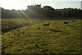
1
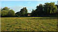
Sheep pasture, Weston-Sub-Edge
Showing the northern corner of the moated site also shown in https://www.geograph.org.uk/search.php?i=169851922 , so what you see does not form part of the scheduled monument. The hot air balloon is above an outbuilding at Dover's Cottage.
Image: © Derek Harper
Taken: 16 Sep 2021
0.02 miles
2
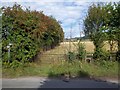
Path meets road
The footpath from Bold Gap meets the minor road in Aston-sub-Edge.
Image: © Michael Dibb
Taken: 22 Aug 2010
0.02 miles
3
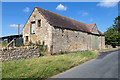
Stone barn on Church Street
A fine stone farm building in Weston Subedge.
The date stone on the front reads 1901.
Image: © David P Howard
Taken: 12 Aug 2016
0.03 miles
4
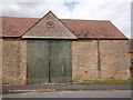
Roadside barn
This lovely barn, part of Middle Farm, is alongside the minor road and carries a datestone of 1901.
Image: © Michael Dibb
Taken: 22 Aug 2010
0.04 miles
5
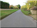
Church Street in Weston-sub-Edge
Looking north-westward.
Image: © Peter Wood
Taken: 6 Nov 2017
0.04 miles
6
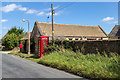
Phone and post boxes on Church Street
Church Street, Weston-sub-Edge.
Image: © David P Howard
Taken: 12 Aug 2016
0.04 miles
7
Sheep, Weston-Sub-Edge
On the moated site also shown at https://www.geograph.org.uk/search.php?i=169851922 . http://www.gatehouse-gazetteer.info/English%20sites/4291.html https://historicengland.org.uk/listing/the-list/list-entry/1003588?section=official-list-entry .
Image: © Derek Harper
Taken: 16 Sep 2021
0.07 miles
8
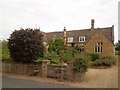
Old school
This was the former school, used as such from 1852 until 1985.
Image: © Michael Dibb
Taken: 22 Aug 2010
0.07 miles
9
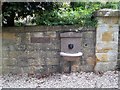
School water
The drinking fountain is inset into the wall of the former school. The plaque gives the dates of the school 1952 to 1985.
Image: © Michael Dibb
Taken: 22 Aug 2010
0.07 miles
10

Pink Horse Chestnut flowers
A closer look.
Image: © David Luther Thomas
Taken: 4 May 2007
0.08 miles