IMAGES TAKEN NEAR TO
Kingcombe Lane, CHIPPING CAMPDEN, GL55 6PN
Introduction
This page details the photographs taken nearby to Kingcombe Lane, GL55 6PN by members of the Geograph project.
The Geograph project started in 2005 with the aim of publishing, organising and preserving representative images for every square kilometre of Great Britain, Ireland and the Isle of Man.

There are currently over 7.5m images from over14,400 individuals and you can help contribute to the project by visiting https://www.geograph.org.uk
Image Map
Images are licensed for reuse under creativecommons.org/licenses/by-sa/2.0
Notes
- Clicking on the map will re-center to the selected point.
- The higher the marker number, the further away the image location is from the centre of the postcode.
Image Listing (21 Images Found)
Images are licensed for reuse under creativecommons.org/licenses/by-sa/2.0
Image
Details
Distance
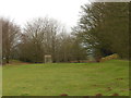
1
Woodland track near Bold Gap
The Cotswold Way does a little loop to the viewpoint just around the corner.
Image: © Bill Boaden
Taken: 19 Jul 2015
0.16 miles
3
Cotswold Way and view towards Chipping Campden
The Cotswold Way (on the right here) leaving Dover's Hill towards the path's northern end at Chipping Campden.
Image: © Trevor Harris
Taken: 20 Jul 2014
0.16 miles
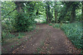
4
Gateway on Dover's Hill
This gateway is at the northern end of Dover's Hill near Bold Gap. A bridleway passes through this gate and continues along the side of Kingscomb Hill.
Image: © Philip Halling
Taken: 19 Jul 2008
0.17 miles
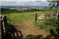
5
Bold Gap
The locality known as Bold Gap has a crossroads of rights of way. The bridleway from The Dingle runs through towards Dover's Hill. A footpath, part of the Cotswold Way runs from the left into Chipping Campden whilst a second footpath descends towards The Lynches Wood and Weston-sub-Edge.
Image: © Michael Dibb
Taken: 22 Aug 2010
0.18 miles
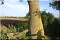
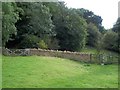
6
Near Bold Gap
The field boundary is the parish boundary between Weston-sub-edge (this side) and Aston Sub Edge. Weston-sub-edge footpath 26 ends here, where it meets a bridleway. This is Aston Subedge bridleway 9 on the far side of the wall, and Weston-sub-edge bridleway 21#1 on this side. Or perhaps the bridleway stays beyond the wall and climbs through the wood, while the gates are for walkers, who climb steps to the right. I recall being confused. The kissing gate, incidentally, had only been installed a few months before this was taken.
Image: © Derek Harper
Taken: 15 Sep 2021
0.18 miles
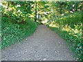
7
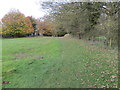
Footpath on Dover's Hill approaching Bold Gap
Looking northward.
Image: © Peter Wood
Taken: 6 Nov 2017
0.18 miles
8
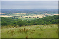
Hillside at Bold Gap
There are views to the north west where the weather is indifferent.
Image: © Bill Boaden
Taken: 19 Jul 2015
0.19 miles
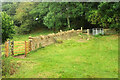
9
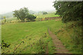
Path, Bold Gap
The steps lead down to the area shown in Image], from where Weston-sub-edge footpath 26 heads left to The Lynches Wood, while straight on is for the B4035 Aston Road via Aston Subedge bridleway 9. Whether these steps form part of Weston-sub-edge bridleway 21#1 I really wouldn't like to say.
Image: © Derek Harper
Taken: 15 Sep 2021
0.19 miles