IMAGES TAKEN NEAR TO
Devereaux Crescent, STROUD, GL5 4PS
Introduction
This page details the photographs taken nearby to Devereaux Crescent, GL5 4PS by members of the Geograph project.
The Geograph project started in 2005 with the aim of publishing, organising and preserving representative images for every square kilometre of Great Britain, Ireland and the Isle of Man.

There are currently over 7.5m images from over14,400 individuals and you can help contribute to the project by visiting https://www.geograph.org.uk
Image Map (Loading...)


Getting Data...Please wait
Leaflet Map data © OpenStreetMap
Images are licensed for reuse under creativecommons.org/licenses/by-sa/2.0
Notes
- Clicking on the map will re-center to the selected point.
- The higher the marker number, the further away the image location is from the centre of the postcode.
Image Listing (18 Images Found)
Images are licensed for reuse under creativecommons.org/licenses/by-sa/2.0
Image
Details
Distance
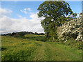
2

Cows above Ebley
The River Frome runs in the valley below on the right.
Image: © Bill Boaden
Taken: 17 Jul 2016
0.20 miles
3
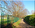
Ebley: Chapel Lane north of the level crossing
North of the level crossing http://www.geograph.org.uk/photo/2768825 Chapel Lane narrows to a path along the perimeter fence of Foxmoor Primary School.
Image: © Jaggery
Taken: 15 Jan 2012
0.20 miles
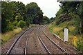
5
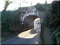
Foxmoor Lane railway bridge, Ebley
The bridge carries a double track railway line over Foxmoor Lane, between Stonehouse station and Stroud station. The identification notice on the bridge is
Ebley Road 103m 61.5ch SWM. A warning triangle on the bridge shows a headroom of 10 feet.
Image: © Jaggery
Taken: 15 Jan 2012
0.20 miles
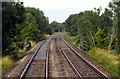
6
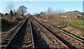
Railway lines west of Ebley level crossing
Viewed from the middle of the level crossing. http://www.geograph.org.uk/photo/2768825
The lines head towards Stonehouse station, about 2km away.
Stroud station is about 3km behind the camera.
Image: © Jaggery
Taken: 15 Jan 2012
0.20 miles
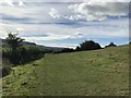
8

The Cotswold Way towards Ryeford
The Cotswold Way, day three 2:05pm
Image: © Ian S
Taken: 19 Apr 2013
0.20 miles
9
The Swindon - Gloucester line at Ebley
Image: © Steve Daniels
Taken: 2 Sep 2009
0.21 miles
10
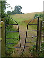
Squeeze gate stile on Cotswold Way
On the Cotswold Way between Westrip and the Frome valley.
Image: © Derek Harper
Taken: 5 Jul 2006
0.21 miles