IMAGES TAKEN NEAR TO
Foxmoor Lane, STROUD, GL5 4PP
Introduction
This page details the photographs taken nearby to Foxmoor Lane, GL5 4PP by members of the Geograph project.
The Geograph project started in 2005 with the aim of publishing, organising and preserving representative images for every square kilometre of Great Britain, Ireland and the Isle of Man.

There are currently over 7.5m images from over14,400 individuals and you can help contribute to the project by visiting https://www.geograph.org.uk
Image Map (Loading...)


Getting Data...Please wait
Leaflet Map data © OpenStreetMap
Images are licensed for reuse under creativecommons.org/licenses/by-sa/2.0
Notes
- Clicking on the map will re-center to the selected point.
- The higher the marker number, the further away the image location is from the centre of the postcode.
Image Listing (11 Images Found)
Images are licensed for reuse under creativecommons.org/licenses/by-sa/2.0
Image
Details
Distance
1
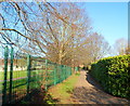
Ebley: Chapel Lane north of the level crossing
North of the level crossing http://www.geograph.org.uk/photo/2768825 Chapel Lane narrows to a path along the perimeter fence of Foxmoor Primary School.
Image: © Jaggery
Taken: 15 Jan 2012
0.13 miles
3
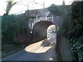
Foxmoor Lane railway bridge, Ebley
The bridge carries a double track railway line over Foxmoor Lane, between Stonehouse station and Stroud station. The identification notice on the bridge is
Ebley Road 103m 61.5ch SWM. A warning triangle on the bridge shows a headroom of 10 feet.
Image: © Jaggery
Taken: 15 Jan 2012
0.19 miles
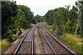
4
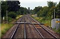
Railway lines west of Ebley level crossing
Viewed from the middle of the level crossing. http://www.geograph.org.uk/photo/2768825
The lines head towards Stonehouse station, about 2km away.
Stroud station is about 3km behind the camera.
Image: © Jaggery
Taken: 15 Jan 2012
0.19 miles
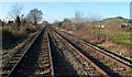
5
Ebley Crossing railway Halt (site), Gloucestershire
Opened in 1903 by the Great Western Railway on the line from Swindon to Gloucester, this station closed in 1964.
View west towards Stonehouse and Gloucester. No trace appears to remain of the two short parallel platforms here.
Image: © Nigel Thompson
Taken: 9 Oct 2021
0.19 miles
6
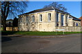
Grade II listed Ebley Chapel
Located on the corner of Chapel Lane and Huntingdon Close, Ebley.
Built as The British School in 1840, extended in 1896, Grade II listed in June 1974.
Image: © Jaggery
Taken: 15 Jan 2012
0.21 miles
7
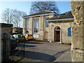
Two plaques, Ebley Chapel
The plaque on the left records that Grade II listed Ebley Chapel http://www.geograph.org.uk/photo/2768813 was built as Ebley British School in 1840. The plaque on the right records the building of the extension in 1896.
Image: © Jaggery
Taken: 15 Jan 2012
0.21 miles
8

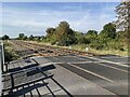
Ebley level crossing
Chapel Lane crosses the railway here, between Stonehouse and Stroud stations.
This is not an automatic level crossing. The instructions on the larger of the two signs on the left is
Stop
Always telephone before crossing with vehicles or animals to find out if there is time to cross.
Tell the signalman if the vehicle is large or slow-moving.
1. Open far gate before crossing with vehicles or animals.
2. Cross quickly.
3. Close and secure gates after use.
The smaller sign shows
Stop
Look
Listen
Do not cross when warning sounds.
Image: © Jaggery
Taken: 15 Jan 2012
0.21 miles
10

Cows above Ebley
The River Frome runs in the valley below on the right.
Image: © Bill Boaden
Taken: 17 Jul 2016
0.23 miles