IMAGES TAKEN NEAR TO
Graces Field, STROUD, GL5 4EN
Introduction
This page details the photographs taken nearby to Graces Field, GL5 4EN by members of the Geograph project.
The Geograph project started in 2005 with the aim of publishing, organising and preserving representative images for every square kilometre of Great Britain, Ireland and the Isle of Man.

There are currently over 7.5m images from over14,400 individuals and you can help contribute to the project by visiting https://www.geograph.org.uk
Image Map
Images are licensed for reuse under creativecommons.org/licenses/by-sa/2.0
Notes
- Clicking on the map will re-center to the selected point.
- The higher the marker number, the further away the image location is from the centre of the postcode.
Image Listing (71 Images Found)
Images are licensed for reuse under creativecommons.org/licenses/by-sa/2.0
Image
Details
Distance
1
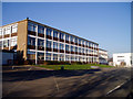
Stroud College
Or "Stroud College in Gloucestershire" as it's officially called, presumably for the benefit of people who don't know where Stroud is. This is the old block of the college, in typical 1960s educational style. On the right they are building a swish new block (I think they demolished an existing building to make room for it): see Image College website: http://www.stroud.ac.uk/index.html
Image: © David Gruar
Taken: 3 Feb 2007
0.04 miles
2
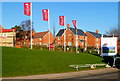
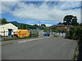
House construction above Stratford Road, Stroud
A mid-January 2012 view of work in progress on new housing.
The yellow sign on a lamppost shows Newland At The Pavilion.
Image: © Jaggery
Taken: 15 Jan 2012
0.04 miles
3
New houses, Stratford Road, Stroud
This is a Newland Homes development named The Pavilion, built on the former
home ground of Stroud Cricket Club, who have relocated.
Image: © Jaggery
Taken: 15 Jan 2012
0.05 miles
4
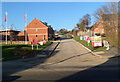
Side road from The Pavilion to the old pavilion, Stroud
The road leads from Stratford Road past new houses in a development named The Pavilion http://www.geograph.org.uk/photo/3542551 towards a former cricket pavilion in what used to be Stroud Cricket Club's ground.
The club has relocated.
Image: © Jaggery
Taken: 15 Jan 2012
0.06 miles
5
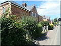
South side, Central Road, Downfield, Stroud
Social housing built between 1921 and 1935 on the site of some allotments.
Image: © Christine Johnstone
Taken: 15 Jul 2022
0.07 miles
6
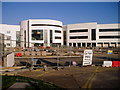
New building, Stroud College
Stroud's further education college is currently building a futuristic-looking new home to complement its existing 1960s block (Image).
Image: © David Gruar
Taken: 3 Feb 2007
0.09 miles
7
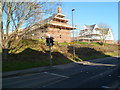
Crossing Cottage, Beard's Lane, Stroud
Built before 1881. The level crossing has been replaced by the footbridge the photographer is on.
Image: © Christine Johnstone
Taken: 15 Jul 2022
0.09 miles
9
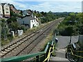
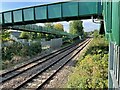
Railway crossing, Beard's Lane, Stroud
The footbridge has replaced the original crossing over the Swindon - Gloucester railway line. This is about 100 metres east of the former Downfield Halt https://maps.nls.uk/view/109726684.
Image: © Christine Johnstone
Taken: 15 Jul 2022
0.10 miles
10
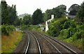
Downfield Crossing railway Halt (site), Gloucestershire
Opened in 1903 by the Great Western Railway on the line from Swindon to Gloucester, this station closed in 1964.
View west towards Cashes reen and Gloucester. The former crossing has been replaced by a footbridge. No trace appears to remain of the two parallel platforms here.
Image: © Nigel Thompson
Taken: 9 Oct 2021
0.11 miles