IMAGES TAKEN NEAR TO
Paganhill, STROUD, GL5 4AX
Introduction
This page details the photographs taken nearby to GL5 4AX by members of the Geograph project.
The Geograph project started in 2005 with the aim of publishing, organising and preserving representative images for every square kilometre of Great Britain, Ireland and the Isle of Man.

There are currently over 7.5m images from over14,400 individuals and you can help contribute to the project by visiting https://www.geograph.org.uk
Image Map
Images are licensed for reuse under creativecommons.org/licenses/by-sa/2.0
Notes
- Clicking on the map will re-center to the selected point.
- The higher the marker number, the further away the image location is from the centre of the postcode.
Image Listing (43 Images Found)
Images are licensed for reuse under creativecommons.org/licenses/by-sa/2.0
Image
Details
Distance
1
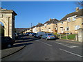
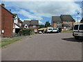
Paganhill Estate houses, Stroud
Viewed from Farmhill Lane. The arch http://www.geograph.org.uk/photo/288265 on the left was erected in 1834 to commemorate the abolition of slavery in the British Colonies.
Image: © Jaggery
Taken: 15 Jan 2012
0.05 miles
2
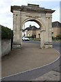
Memorial Arch on Paganhill, Stroud
This arch was constructed in 1834 to commemorate the abolition of slavery in the British colonies and was repaired in 2001. It formerly formed the entrance to Farmhill Park, a large house.
Image: © James Purkiss
Taken: 5 Sep 2005
0.10 miles
3
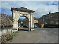
Anti-slavery arch at the entrance to Paganhill estate
The inscription on the arch reads 'Erected to commemorate the abolition of slavery in the British colonies the first of August A.D. MDCCCXXXIV.' A nearby plaque reads ' Stroud Preservation Trust / The Anti Slavery Arch / Built 1834 / by Henry Wyatt / Unique in the UK / Restored 2001'. The arch is listed Grade II* [2*, which is higher than 2].
Image: © Christine Johnstone
Taken: 15 Jul 2022
0.11 miles
4
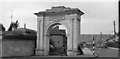
The memorial arch in Stroud circa 1964.
Scanned from a 60mm black & white negative.
Image: © Antony Ewart Smith
Taken: Unknown
0.11 miles
5
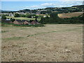
On the northern edge of Stroud
Houses built this century at the end of Wheelers Walk
Image: © Christine Johnstone
Taken: 15 Jul 2022
0.11 miles
6
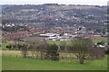
Stroud view
General view of Stroud. The clump of buildings in the centre of the picture belong to Archway School. The pair of white lines looking like a giant rugby goal are chimney stacks belonging to the Millikan factory, a wool cloth mill. The hill in the background is Rodborough Hill.
Image: © Peter Kwan
Taken: 13 Mar 2005
0.11 miles
7
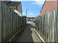
Public footpath to Wheelers Walk and Wheelers Rise
The northern edge of Stroud.
Image: © Christine Johnstone
Taken: 15 Jul 2022
0.12 miles
8
The northern edge of Stroud
Where the newish houses on Wheelers Walk meet the Cotswolds AONB.
Image: © Christine Johnstone
Taken: 15 Jul 2022
0.12 miles
9
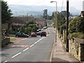
Farmhill Lane, Stroud
This is the road from Whiteshill dropping towards the Paganhill area of Stroud. Traffic is waiting to turn out of Mathews Way.
Image: © Derek Harper
Taken: 18 Sep 2008
0.12 miles
10
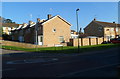
Corner of Farmhill Lane and Mathews Way, Stroud
Mathews Way is on the right.
Image: © Jaggery
Taken: 15 Jan 2012
0.13 miles