IMAGES TAKEN NEAR TO
Paganhill, STROUD, GL5 4AS
Introduction
This page details the photographs taken nearby to GL5 4AS by members of the Geograph project.
The Geograph project started in 2005 with the aim of publishing, organising and preserving representative images for every square kilometre of Great Britain, Ireland and the Isle of Man.

There are currently over 7.5m images from over14,400 individuals and you can help contribute to the project by visiting https://www.geograph.org.uk
Image Map (Loading...)


Getting Data...Please wait
Leaflet Map data © OpenStreetMap
Images are licensed for reuse under creativecommons.org/licenses/by-sa/2.0
Notes
- Clicking on the map will re-center to the selected point.
- The higher the marker number, the further away the image location is from the centre of the postcode.
Image Listing (42 Images Found)
Images are licensed for reuse under creativecommons.org/licenses/by-sa/2.0
Image
Details
Distance
1
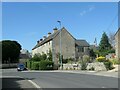
1-5 Maypole Terrace, Park End, Stroud
A row of five three-storey houses from the early 1800s. Listed Grade II [two].
Image: © Christine Johnstone
Taken: 15 Jul 2022
0.00 miles
2
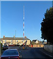
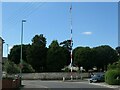
Paganhill maypole, Stroud
Viewed from Ruscombe Road. The red white and blue maypole was erected alongside Maypole Terrace (out of shot on the left) in May 2004 to celebrate Stroud's 700th birthday.
Image: © Jaggery
Taken: 15 Jan 2012
0.01 miles
3
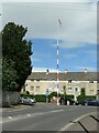
Paganhill maypole, Stroud, from the south-east
Currently being used as a flagpole. A plaque near the base reads 'This maypole was erected in May 2004 preserving a tradition in Paganhill dating back to the mid 17th century. It was made possible by the generosity of Mr Tim Lodge and celebrated Stroud's 700th birthday'.
Image: © Christine Johnstone
Taken: 15 Jul 2022
0.01 miles
4
Paganhill maypole, Stroud, from the north-east
Currently being used as a flagpole. A plaque near the base reads 'This maypole was erected in May 2004 preserving a tradition in Paganhill dating back to the mid 17th century. It was made possible by the generosity of Mr Tim Lodge and celebrated Stroud's 700th birthday'.
Image: © Christine Johnstone
Taken: 15 Jul 2022
0.01 miles
5
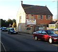
A.S.Cooke, Stroud
Ruscombe Road office of A S Cooke & Co Ltd, building and maintenance contractors, established 1881.
Image: © Jaggery
Taken: 15 Jan 2012
0.01 miles
6
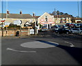
Autodeals of Stroud
User car dealer in Stratford Road, opposite the mini-roundabout at the Paganhill roundabout.
Image: © Jaggery
Taken: 15 Jan 2012
0.04 miles
7
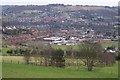
Stroud view
General view of Stroud. The clump of buildings in the centre of the picture belong to Archway School. The pair of white lines looking like a giant rugby goal are chimney stacks belonging to the Millikan factory, a wool cloth mill. The hill in the background is Rodborough Hill.
Image: © Peter Kwan
Taken: 13 Mar 2005
0.04 miles
8
Croft Farragher Upholstery and Stroud Furniture Restoration, Stroud
Shop at 143 Stratford Road, Stroud.
Image: © Jaggery
Taken: 15 Jan 2012
0.05 miles
9
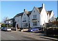
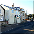
The Rose Inn, Stroud
Located at the top (northern) end of Paganhill Lane, The Rose Inn dates from 1822.
Image: © Jaggery
Taken: 15 Jan 2012
0.05 miles
10
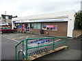
Tesco Express at Pagan Hill, Stroud
Image: © Humphrey Bolton
Taken: 11 Jul 2017
0.05 miles