IMAGES TAKEN NEAR TO
Winchcombe, CHELTENHAM, GL54 5AX
Introduction
This page details the photographs taken nearby to GL54 5AX by members of the Geograph project.
The Geograph project started in 2005 with the aim of publishing, organising and preserving representative images for every square kilometre of Great Britain, Ireland and the Isle of Man.

There are currently over 7.5m images from over14,400 individuals and you can help contribute to the project by visiting https://www.geograph.org.uk
Image Map
Images are licensed for reuse under creativecommons.org/licenses/by-sa/2.0
Notes
- Clicking on the map will re-center to the selected point.
- The higher the marker number, the further away the image location is from the centre of the postcode.
Image Listing (13 Images Found)
Images are licensed for reuse under creativecommons.org/licenses/by-sa/2.0
Image
Details
Distance
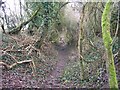
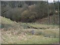
1

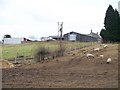
Pinnock medieval village
This is the site of a medieval village, and you can make out some irregularities in the landscape. The track to the right is the bridleway towards Temple Guiting. The farm access road to the left is not a public right of way.
Image: © Graham Horn
Taken: 11 Sep 2012
0.02 miles
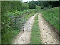
3
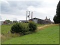
Pinnock Farm
The view is a little green than the previous image taken from this spot in February Image
Image: © Michael Dibb
Taken: 18 Aug 2010
0.02 miles
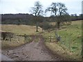
4
Site of lost village
The footpath crosses the access track to Pinnock Farm. The view here is to west. Part of the lost medieval village was in this area.
Image: © Michael Dibb
Taken: 25 Feb 2010
0.05 miles
5
Site of lost village
The footpath crosses the access track to Pinnock Farm. The view here is to east. Part of the lost medieval village was in this area.
Image: © Michael Dibb
Taken: 25 Feb 2010
0.07 miles
6
Out of the trees
The footpath finally exits the trees and emerges into open fields as it approaches the site of the lost medieval village.
Image: © Michael Dibb
Taken: 25 Feb 2010
0.10 miles
7
Blocked track
The flimsy wire fence placed across the track is no barrier to walkers, nor, probably, to sheep.
Image: © Michael Dibb
Taken: 18 Aug 2010
0.13 miles
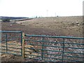
8
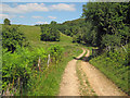
Track to Pinnock Farm
Heading north-east along the valley bottom. The sharp bend just ahead leads to Pinnock Farm just off to the left.
Image: © Trevor Rickard
Taken: 16 Aug 2010
0.14 miles
9
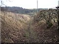
Path to Temple Guiting
The path, possibly an old hollow way, continues on its way to Temple Guiting. There has obviously been no clearing done for some time and the growth is threatening to overwhelm the path.
Image: © Michael Dibb
Taken: 25 Feb 2010
0.16 miles
10
Towards Waterloo Larch
In the bottom of the valley, the footpath divides. One branch follows the track whilst the other heads towards the woodland known as Waterloo Larch.
Image: © Michael Dibb
Taken: 25 Feb 2010
0.17 miles