IMAGES TAKEN NEAR TO
Cassey Compton, CHELTENHAM, GL54 4DE
Introduction
This page details the photographs taken nearby to Cassey Compton, GL54 4DE by members of the Geograph project.
The Geograph project started in 2005 with the aim of publishing, organising and preserving representative images for every square kilometre of Great Britain, Ireland and the Isle of Man.

There are currently over 7.5m images from over14,400 individuals and you can help contribute to the project by visiting https://www.geograph.org.uk
Image Map
Images are licensed for reuse under creativecommons.org/licenses/by-sa/2.0
Notes
- Clicking on the map will re-center to the selected point.
- The higher the marker number, the further away the image location is from the centre of the postcode.
Image Listing (44 Images Found)
Images are licensed for reuse under creativecommons.org/licenses/by-sa/2.0
Image
Details
Distance
1
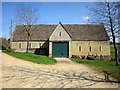
Barn at Cassey Compton
Another view of the barn shown in Image] http://list.historicengland.org.uk/resultsingle.aspx?uid=1341328&searchtype=mapsearch . Bridleway KWR 29/2 follows a track on the left side of the barn.
Image: © Derek Harper
Taken: 8 Apr 2015
0.04 miles
2
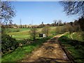
Bridleway at Cassey Compton
Only 138 metres long, according to http://www.rowmaps.com/showmap.php?place=Cassey%20Compton&map=OS&lat=51.8367&lon=1.935&lonew=W , this track links King's Head Lane to the White Way. Here it seems to be raised on a causeway as it crosses a tributary of the Coln, the Compton Abdale stream or Dene Brook. The number is KWR 29/2.
Image: © Derek Harper
Taken: 8 Apr 2015
0.04 miles
3
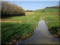
Compton Abdale stream
Or the Dene Brook (see http://www.british-history.ac.uk/vch/glos/vol9/pp248-279 ), but not now named on maps, looking upstream from the stretch of bridleway shown in Image
Image: © Derek Harper
Taken: 8 Apr 2015
0.05 miles
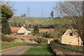
5
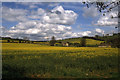
Oil seed rape and typical Cotswold barn at Cassey Compton
Image: © Colin Park
Taken: 27 Apr 2000
0.06 miles
6
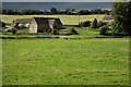
Barn at Cassey Compton
Cotswold stone built barn at Cassey Compton, reminiscent of a tithe barn.
Image: © Philip Halling
Taken: 12 Jul 2008
0.06 miles
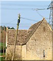
7
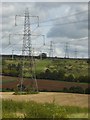
Electricity pylons above Cassey Compton
Electricity pylons crossing farmland near Cassey Compton.
Image: © Philip Halling
Taken: 23 Aug 2017
0.06 miles
8

Barn at Cassey Compton
One of the C18 barns shown in Image] http://list.historicengland.org.uk/resultsingle.aspx?uid=1341328&searchtype=mapsearch . " Cross-shaped plan ... projecting gabled porches on east and west each with double width openings and ventilation slits towards apex of porch gables in side walls and gable ends ..."
Image: © Derek Harper
Taken: 8 Apr 2015
0.08 miles
9
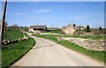
Barns at Cassey Compton
The two C18 barns are listed: http://list.historicengland.org.uk/resultsingle.aspx?uid=1252020&searchtype=mapsearch (left) and http://list.historicengland.org.uk/resultsingle.aspx?uid=1341328&searchtype=mapsearch ; see also Image] and Image On the left is the telegraph pole on which the kestrel shown in Image] was perched; it's flown off now. The lane, to Withington, is King's Head Lane.
Image: © Derek Harper
Taken: 8 Apr 2015
0.08 miles
10
Kestrel at Cassey Compton
Atop a telegraph pole near Cassey Compton House, with a fine C18 barn http://list.historicengland.org.uk/resultsingle.aspx?uid=1341328&searchtype=mapsearch in the background.
Image: © Derek Harper
Taken: 8 Apr 2015
0.10 miles