IMAGES TAKEN NEAR TO
Yanworth, CHELTENHAM, GL54 3LG
Introduction
This page details the photographs taken nearby to GL54 3LG by members of the Geograph project.
The Geograph project started in 2005 with the aim of publishing, organising and preserving representative images for every square kilometre of Great Britain, Ireland and the Isle of Man.

There are currently over 7.5m images from over14,400 individuals and you can help contribute to the project by visiting https://www.geograph.org.uk
Image Map
Images are licensed for reuse under creativecommons.org/licenses/by-sa/2.0
Notes
- Clicking on the map will re-center to the selected point.
- The higher the marker number, the further away the image location is from the centre of the postcode.
Image Listing (42 Images Found)
Images are licensed for reuse under creativecommons.org/licenses/by-sa/2.0
Image
Details
Distance
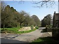
1
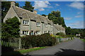
Cottages at Yanworth
Church Hill Cottages are two pairs of semi-detached houses just up the hill from the church and Church Farm.
Image: © Derek Harper
Taken: 8 Apr 2015
0.01 miles
3
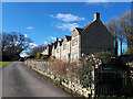
Houses at Yanworth
Cotswold stone built houses near Yanworth church, the tower of which can be seen in the background.
Image: © Philip Halling
Taken: 12 Jul 2008
0.03 miles
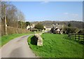
5
Lane in Yanworth
On the right is the former school house, presumably the one referred to at http://www.british-history.ac.uk/vch/glos/vol9/pp91-106 and possibly built around 1875. A view from the Macmillan Way, which doesn't actually go down this lane.
Image: © Derek Harper
Taken: 8 Apr 2015
0.05 miles
6
Church and farm, Yanworth
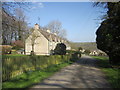
Taken further along the lane shown in Image], with the Church of St Michael http://list.historicengland.org.uk/resultsingle.aspx?uid=1089831&searchtype=mapsearch , a listed barn http://list.historicengland.org.uk/resultsingle.aspx?uid=1154366&searchtype=mapsearch , and Church Farmhouse http://list.historicengland.org.uk/resultsingle.aspx?uid=1089833&searchtype=mapsearch .
Image: © Derek Harper
Taken: 8 Apr 2015
0.06 miles
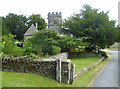
7
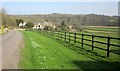
Approaching Church Farm, Yanworth
Down the lane shown in Image
Image: © Derek Harper
Taken: 8 Apr 2015
0.06 miles
8
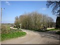
Junction at Yanworth
Bridleway KYA 1/1 crosses a back lane as it enters the village, with a small wood in the angle. The signpost advertises a footpath as well as the bridleway, though I can't spot one leading from this crossroads on the map.
Image: © Derek Harper
Taken: 8 Apr 2015
0.06 miles
9
St. Michael's Church, Yanworth
The Grade II listed building dates to the 12th century.
Image: © pam fray
Taken: 16 Jul 2019
0.07 miles
10
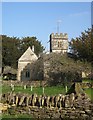
Church of St. Michael, Yanworth
Seen from the west. The church is grade II* listed http://list.historicengland.org.uk/resultsingle.aspx?uid=1089831&searchtype=mapsearch . Parts date from C12.
Image: © Derek Harper
Taken: 8 Apr 2015
0.07 miles