IMAGES TAKEN NEAR TO
Bourton-on-the-Water, CHELTENHAM, GL54 3BZ
Introduction
This page details the photographs taken nearby to GL54 3BZ by members of the Geograph project.
The Geograph project started in 2005 with the aim of publishing, organising and preserving representative images for every square kilometre of Great Britain, Ireland and the Isle of Man.

There are currently over 7.5m images from over14,400 individuals and you can help contribute to the project by visiting https://www.geograph.org.uk
Image Map
Images are licensed for reuse under creativecommons.org/licenses/by-sa/2.0
Notes
- Clicking on the map will re-center to the selected point.
- The higher the marker number, the further away the image location is from the centre of the postcode.
Image Listing (36 Images Found)
Images are licensed for reuse under creativecommons.org/licenses/by-sa/2.0
Image
Details
Distance
1
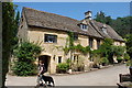
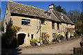
The Windrush Way passes former mill
Little Aston Mill, now a private residence.
Image: © Trevor Harris
Taken: 24 Jul 2014
0.02 miles
2
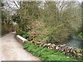
River Windrush
The minor road gives access to the mill on the far side of the river.
Image: © Michael Dibb
Taken: 26 Apr 2010
0.04 miles
3
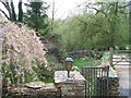
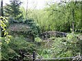
The mill race
No longer used, the race is seen from the bridge at Little Aston Mill.
Image: © Michael Dibb
Taken: 26 Apr 2010
0.04 miles
4
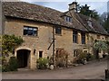
Little Aston Mill
The mill is alongside the River Windrush. Three long distance paths cross the river at this point. The combined Gloucestershire Way and Macmillan Way come south from Lower Slaughter and continue to Cold Aston. The Windrush Way changes from the south bank (west of the bridge) to the north bank (east of the bridge).
Image: © Michael Dibb
Taken: 26 Apr 2010
0.05 miles
5
Stream at Aston Mill
This stream is part of the River Windrush. Opposite an old mill now a private residence near Aston Farm.
Image: © Graham Horn
Taken: 29 Apr 2007
0.05 miles
7
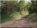
Footpath to Bourton-on-the-Water
This footpath branches off the minor road and heads towards Bourton-on-the-Water via the south bank of the River Windrush. The Windrush Way long distance path also goes to Bourton-on-the-Water but it runs on the north bank.
Image: © Michael Dibb
Taken: 26 Apr 2010
0.07 miles
8
![Once were trains [1]](https://s0.geograph.org.uk/geophotos/01/85/38/1853812_70e2ea83_120x120.jpg)
Once were trains [1]
It is difficult to believe that there was once a bridge under a railway at this point. The railway was the Cheltenham and Banbury Direct which closed and was dismantled in the 1960s. Almost every trace has disappeared except for a few courses of brickwork on either side of the road.
Image: © Michael Dibb
Taken: 26 Apr 2010
0.07 miles
9
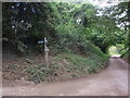
Path junction sign near Lower Aston Mill and Aston Farm
Image: © Liz Stone
Taken: 22 Aug 2011
0.07 miles
10
![Once were trains [2]](https://s2.geograph.org.uk/geophotos/01/85/38/1853822_068c865b_120x120.jpg)
Once were trains [2]
It is difficult to believe that there was once a bridge under a railway at this point. The railway was the Cheltenham and Banbury Direct which closed and was dismantled in the 1960s. Almost every trace has disappeared except for a few courses of brickwork on either side of the road. This is the west side of the road.
Image: © Michael Dibb
Taken: 26 Apr 2010
0.07 miles