IMAGES TAKEN NEAR TO
Slaughter Pike, CHELTENHAM, GL54 2FD
Introduction
This page details the photographs taken nearby to Slaughter Pike, GL54 2FD by members of the Geograph project.
The Geograph project started in 2005 with the aim of publishing, organising and preserving representative images for every square kilometre of Great Britain, Ireland and the Isle of Man.

There are currently over 7.5m images from over14,400 individuals and you can help contribute to the project by visiting https://www.geograph.org.uk
Image Map
Images are licensed for reuse under creativecommons.org/licenses/by-sa/2.0
Notes
- Clicking on the map will re-center to the selected point.
- The higher the marker number, the further away the image location is from the centre of the postcode.
Image Listing (19 Images Found)
Images are licensed for reuse under creativecommons.org/licenses/by-sa/2.0
Image
Details
Distance
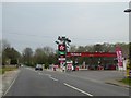
1
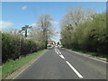
A429 approaches the Murco Filling Station
Image: © Stuart Logan
Taken: 13 Apr 2014
0.02 miles
2
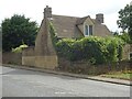
Pike House, A429, Bourton on the Water
A former Toll House on the Fosse Way (A429) near the villages of Upper & Lower Slaughter.
It served the Foss & Cross Turnpike Trust in the 19ᵗʰ C.
Milestone Society National ID: GL.LOW
Image: © Mr Red
Taken: 6 Jul 2023
0.03 miles
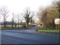
3
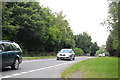
A429 heading north
The Roman Foss Way.
Image: © Robin Webster
Taken: 30 May 2021
0.03 miles
4
Murco filling station north of Bourton-on-the-Water
Image: © David Smith
Taken: 21 Jul 2013
0.03 miles
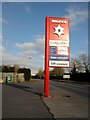
5
Texaco filling station north of Bourton-on-the-Water
This was formerly a Murco filling station Image
Image: © David Smith
Taken: 7 May 2016
0.04 miles
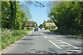
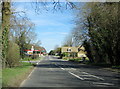
6
The road to the Slaughters
Seen from the opposite side of the Fosse Way, the road leads to Lower Slaughter and Upper Slaughter. The name of Slaughter has no connection with blood but is derived from the old English word Slohtre meaning a muddy place, which it may once have been.
Image: © Michael Dibb
Taken: 13 Dec 2009
0.05 miles
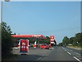
7
Fosse Slaughter Garage
The Fosse Garage along the notorious A429 Fosse Way looking North, north of Lower Slaughter, in the distance a 50mph speed camera
Image: © Chris
Taken: 28 Jan 2011
0.06 miles
8
A429 Fosse Way Approaching Turning For The Slaughters
Image: © Roy Hughes
Taken: 25 Mar 2017
0.06 miles
9
The A429 Fosse Way
Seen from the end of the lane from Wyck Rissington.
Image: © Trevor Harris
Taken: 25 Jul 2014
0.13 miles
10

A429 Fosse Way Just North of Bourton-on-the-Water
Image: © Roy Hughes
Taken: 25 Mar 2017
0.13 miles