IMAGES TAKEN NEAR TO
Letch Hill Drive, CHELTENHAM, GL54 2DQ
Introduction
This page details the photographs taken nearby to Letch Hill Drive, GL54 2DQ by members of the Geograph project.
The Geograph project started in 2005 with the aim of publishing, organising and preserving representative images for every square kilometre of Great Britain, Ireland and the Isle of Man.

There are currently over 7.5m images from over14,400 individuals and you can help contribute to the project by visiting https://www.geograph.org.uk
Image Map
Images are licensed for reuse under creativecommons.org/licenses/by-sa/2.0
Notes
- Clicking on the map will re-center to the selected point.
- The higher the marker number, the further away the image location is from the centre of the postcode.
Image Listing (430 Images Found)
Images are licensed for reuse under creativecommons.org/licenses/by-sa/2.0
Image
Details
Distance
1
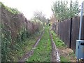
Monarch's Way
The Monarch's Way long distance path heads out of Bourton-on-the-Water towards Clapton-on-the-Hill. The Monarch's Way is a 615-mile long-distance footpath that approximates the escape route taken by King Charles II in 1651 after being defeated in the Battle of Worcester. The houses of the right face onto Letch Hill Drive.
Image: © Michael Dibb
Taken: 17 Nov 2009
0.02 miles
2
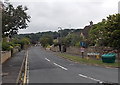
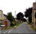
Letch Hill Drive, Bourton-on-the-Water
Viewed from the corner of Letch Lane. Letch Hill Drive is a dead-end road,
extending for 220 metres to the edge of residential Bourton-on-the-Water.
Image: © Jaggery
Taken: 5 Aug 2014
0.04 miles
3
End of Gasworks Lane
Surprisingly, these new houses have been given the name "Meadow View" not "Gasworks Lane". I wonder why? Two footpaths leave Bourton here, one through the gate to the left and one between the new houses and off to the right.
Image: © Graham Horn
Taken: 12 Sep 2012
0.04 miles
4
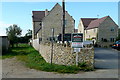
Meadow View
The houses are accurately named, but they are at the end of Gasworks Lane.
Image: © Graham Horn
Taken: 12 Sep 2012
0.04 miles
5
Letch Lane, Bourton-on-the-Water
Looking west from the junction of Victoria Street and Letch Hill Drive.
Image: © Jaggery
Taken: 5 Aug 2014
0.09 miles
6
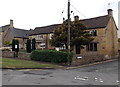
Corner of Victoria Street and Bow Lane, Bourton-on-the-Water
Bow Cottage is on the corner. Appletree Cottage is next door.
Image: © Jaggery
Taken: 5 Aug 2014
0.12 miles
7
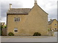
House in Clapton Row, Bourton-on-the-Water
I was informed that this was once the police station but I can find no evidence to back up this claim.
Image: © pam fray
Taken: 9 Sep 2016
0.12 miles
8
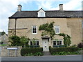
Ghostly impression
This house in Victoria Street has had some alteration over the years, with the stonework keeping the impression.
Image: © Neil Owen
Taken: 6 Aug 2014
0.12 miles
9
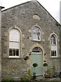
Homely chapel
The former chapel in Clapton Row has been released and is now a private house. The inscription stone above the window proclaims it as a Christadelphian Meeting Room in 1904, but the chapel is older than that and is marked on maps as a Primitive Methodist chapel.
Image: © Neil Owen
Taken: 6 Aug 2014
0.12 miles
10
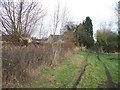
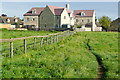
Edge of town
The Monarch's Way long distance path finally reaches open countryside. The last of the houses of Bourton-on-the-Water on the left are at the end of Letch Hill Drive.
Image: © Michael Dibb
Taken: 17 Nov 2009
0.12 miles