IMAGES TAKEN NEAR TO
Lower Swell, CHELTENHAM, GL54 1LF
Introduction
This page details the photographs taken nearby to GL54 1LF by members of the Geograph project.
The Geograph project started in 2005 with the aim of publishing, organising and preserving representative images for every square kilometre of Great Britain, Ireland and the Isle of Man.

There are currently over 7.5m images from over14,400 individuals and you can help contribute to the project by visiting https://www.geograph.org.uk
Image Map
Images are licensed for reuse under creativecommons.org/licenses/by-sa/2.0
Notes
- Clicking on the map will re-center to the selected point.
- The higher the marker number, the further away the image location is from the centre of the postcode.
Image Listing (61 Images Found)
Images are licensed for reuse under creativecommons.org/licenses/by-sa/2.0
Image
Details
Distance
1
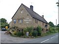
Inn, Lower Swell
The Golden Ball Inn has been a public house for over 100 years in a building constructed in the 17th century.
Image: © Michael Dibb
Taken: 15 Jun 2010
0.05 miles
4
Towards the church
From the driveway to Bowl Farm, this short footpath leads to the church.
Image: © Michael Dibb
Taken: 7 Feb 2010
0.07 miles
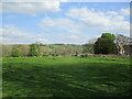
5
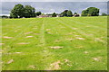
Field at Lower Swell
Recently mown field at Lower Swell.
Image: © Philip Halling
Taken: 15 Jul 2012
0.07 miles
6
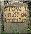
Old Milestone by the B4068, Lower Swell, Swell Parish
Metal plate attached to stone post by the B4068, in parish of SWELL (COTSWOLD District), Lower Swell; opposite Old Farmhouse Hotel, on narrow verge by low wall, on South side of road. Stow iron plate, erected by the Foss & Cross (Stow on the Wold) turnpike trust in the 19th century.
Inscription reads:-
STOW. 1
GLO,R 24
CHELT,M 17
Grade II listed. List Entry Number: 1341077
https://historicengland.org.uk/listing/the-list/list-entry/1341077
Milestone Society National ID: GL_SWCM01.
Image: © J Stanbridge
Taken: 11 Apr 2010
0.09 miles
7
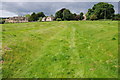
Ancient road? Lower Swell
To the east of the church at Lower Swell there is some evidence of earthworks including this which has the appearance of an old sunken road or track.
Image: © Philip Halling
Taken: 15 Jul 2012
0.09 miles
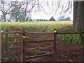
9
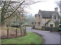
Driveway and lodge
The driveway to Bowl Farm exits onto the B4077 by the side of the gate lodge.
Image: © Michael Dibb
Taken: 7 Feb 2010
0.10 miles
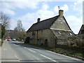
10
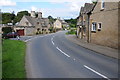
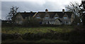
Lower Swell
The Cotswold village of Lower Swell.
Image: © Philip Halling
Taken: 15 Jul 2012
0.11 miles