IMAGES TAKEN NEAR TO
Hill Close, STROUD, GL5 3PG
Introduction
This page details the photographs taken nearby to Hill Close, GL5 3PG by members of the Geograph project.
The Geograph project started in 2005 with the aim of publishing, organising and preserving representative images for every square kilometre of Great Britain, Ireland and the Isle of Man.

There are currently over 7.5m images from over14,400 individuals and you can help contribute to the project by visiting https://www.geograph.org.uk
Image Map
Images are licensed for reuse under creativecommons.org/licenses/by-sa/2.0
Notes
- Clicking on the map will re-center to the selected point.
- The higher the marker number, the further away the image location is from the centre of the postcode.
Image Listing (48 Images Found)
Images are licensed for reuse under creativecommons.org/licenses/by-sa/2.0
Image
Details
Distance
1
Kitesnest Lane, Lightpill
Ascending from the A46 Bath Road.
Image: © Jaggery
Taken: 18 Oct 2015
0.06 miles
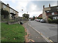
2
Houses on the corner of Kitesnest Lane and Bath Road, Lightpill
Lightpill is part of Rodborough civil parish in the district of Stroud,
and is part of the Stroud urban area along with Stroud and Cainscross.
Image: © Jaggery
Taken: 18 Oct 2015
0.07 miles
3
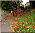
Autumn bank in Lightpill
A mid-October 2015 view of dead leaves on a grassy bank above the A46 Bath Road.
Close together are a red phonebox, red pillarbox http://www.geograph.org.uk/photo/4709331 and green bus shelter.
Image: © Jaggery
Taken: 18 Oct 2015
0.07 miles
4
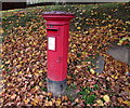
Queen Elizabeth II pillarbox amid dead leaves, Lightpill
A mid-October 2015 view of this http://www.geograph.org.uk/photo/4709337 location.
Image: © Jaggery
Taken: 18 Oct 2015
0.07 miles
5
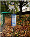
Lightpill bus stop and shelter
Located here http://www.geograph.org.uk/photo/4709337 alongside the A46 Bath Road near the corner of Kitesnest Lane.
Image: © Jaggery
Taken: 18 Oct 2015
0.07 miles
6
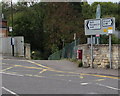
Bath Road direction sign, Lightpill
Facing the Kitesnest Lane junction. Left along the A46 Bath Road for Nailsworth and Bath, right for Stroud. Lightpill is part of Rodborough civil parish in the district of Stroud, and is part of the Stroud urban area along with Stroud and Cainscross.
Image: © Jaggery
Taken: 18 Oct 2015
0.08 miles
7
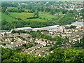
Lightpill, near Stroud
The housing in this image is partly inside this square, that to the left of the diagonal line of trees in the centre of the picture. The commercial/industrial development is west of Dudbridge Road and is outside the square.
Image: © Brian Robert Marshall
Taken: 14 May 2008
0.08 miles
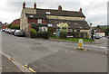
8
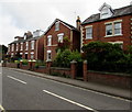
Bath Road houses, Lightpill
Near the Kitesnest Lane junction.
Image: © Jaggery
Taken: 18 Oct 2015
0.08 miles
9
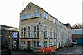
Lightpill Mill
A large complex now better known as the Bath Road Industrial Estate. This former textile (woollen) mill is at its heart and fortunately it is possible to get a reasonable view. The mill is Listed Grade II.
Image: © Chris Allen
Taken: 17 Jan 2010
0.10 miles
10
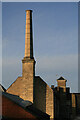
Chimney at Lightpill Mill
A large complex now better known as the Bath Road industrial Estate. This former textile (woollen) mill is at its heart and fortunately it is possible to get a reasonable view. The mill is Listed Grade II.
Image: © Chris Allen
Taken: 17 Jan 2010
0.10 miles