IMAGES TAKEN NEAR TO
Old Bath Road, CHELTENHAM, GL53 7DP
Introduction
This page details the photographs taken nearby to Old Bath Road, GL53 7DP by members of the Geograph project.
The Geograph project started in 2005 with the aim of publishing, organising and preserving representative images for every square kilometre of Great Britain, Ireland and the Isle of Man.

There are currently over 7.5m images from over14,400 individuals and you can help contribute to the project by visiting https://www.geograph.org.uk
Image Map
Images are licensed for reuse under creativecommons.org/licenses/by-sa/2.0
Notes
- Clicking on the map will re-center to the selected point.
- The higher the marker number, the further away the image location is from the centre of the postcode.
Image Listing (21 Images Found)
Images are licensed for reuse under creativecommons.org/licenses/by-sa/2.0
Image
Details
Distance
1
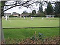
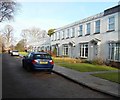
Cheltenham Croquet Club
Located on the Old Bath Road near Naunton Park, the Cheltenham Croquet Club is one of the oldest and best equipped in the country. It is the home of the Croquet Association and has hosted Test Matches and even the World Championships.
Image: © Stephen Bowden
Taken: 16 Apr 2005
0.07 miles
2
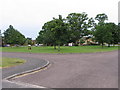
Charlton Park Green
The Charlton Park estate is built on land purchased from Charlton Park Convent, originally a large house and estate built in the 18th century. The plaque on the green is an engraving of the house as it was in the eighteen hundreds with some historical information.
Image: © Terry Jacombs
Taken: 4 Aug 2005
0.07 miles
3
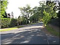
Charlton Park Gate
A private road, one of the most exclusive areas of Cheltenham.
Image: © Terry Jacombs
Taken: 25 Sep 2007
0.08 miles
5
Naunton Park Close, Cheltenham
These 1960s/1970s "period" houses are in a quiet private cul-de-sac looking out over Naunton Park.
Image: © Terry Jacombs
Taken: 27 Jan 2009
0.12 miles
6
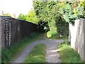
Old Bath Road to Mead Road footpath
The footpath runs between the gardens of houses on the left and a large area of allotments on the right.
Image: © Terry Jacombs
Taken: 25 Sep 2007
0.12 miles
7
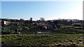
Asquith Road Allotments
The allotments cover all the ground south of Naunton Park between the Old Bath Road and Asquith Road.
Image: © Terry Jacombs
Taken: 18 Jan 2009
0.17 miles
8
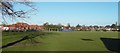
Naunton Park Playing Fields and Playground
The playing fields host three football pitches during the football season. Naunton Park School can be seen behind the playground areas.
Image: © Terry Jacombs
Taken: 18 Jan 2009
0.18 miles
9
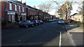
Naunton Park Road
The houses are mostly 1920s/1930s with a few 1960s/1970s ones seen here on the right of the photograph
Image: © Terry Jacombs
Taken: 18 Jan 2009
0.19 miles
10
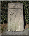
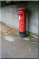
Old Boundary Marker
Municipal Boundary Marker on the north side of the junction where Greenhills Road meets Charlton Lane. The boundary of Cheltenham and Charlton Kings parish. Inscribed CHELTENHAM on the left, G. C. C. on the right (both vertically with a vertical dividing line between them) and B. OF C. / 1935 at the top.
Milestone Society National ID: GL_CMCK01pb
Image: © Mr Red
Taken: 11 Mar 2019
0.20 miles