IMAGES TAKEN NEAR TO
Thrupp Lane, STROUD, GL5 2DG
Introduction
This page details the photographs taken nearby to Thrupp Lane, GL5 2DG by members of the Geograph project.
The Geograph project started in 2005 with the aim of publishing, organising and preserving representative images for every square kilometre of Great Britain, Ireland and the Isle of Man.

There are currently over 7.5m images from over14,400 individuals and you can help contribute to the project by visiting https://www.geograph.org.uk
Image Map
Images are licensed for reuse under creativecommons.org/licenses/by-sa/2.0
Notes
- Clicking on the map will re-center to the selected point.
- The higher the marker number, the further away the image location is from the centre of the postcode.
Image Listing (42 Images Found)
Images are licensed for reuse under creativecommons.org/licenses/by-sa/2.0
Image
Details
Distance
1
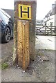
Boundary Marker, Thrupp Lane, Thrupp
At the left-hand gatepost of Nᴼ. 98. Dating from between 1914 and 1974, probably 1936 when other boundaries were moved in the area.
It would have signified the limit of Stroud Urban District Council, from Stroud Rural. The Southern face has been ground off to some extent, but can be seen to read "Cainscross" from what is left. This would have been mostly removed because Cainscrioss is (& was) a parish on the Western side of Stroud. This is at the SE. Thrupp was spelled Thrup in the mid 19ᵗʰ C.
Note from a Geograph surfer "These markers and signposts were made in a small factory in the car park behind the old Police Station in Stonehouse, below the railway embankment on the Gloucester side of Burdett Road Station. Is it possible that this is a re-use of an old Cainscross signpost. Parts of signs lay around the building before it was demolished." (in the 50s).
Inscription: S. U / D. C // (Cainsc?os?) // Stroud
Milestone Society National ID: GL_BRITHR01pb
Image: © Mr Red
Taken: 22 Mar 2023
0.03 miles
2
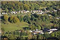
Thrupp
Thrupp in the Golden Valley viewed from Rodborough.
Image: © Philip Halling
Taken: 11 Oct 2014
0.10 miles
3
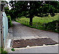
Grid across a lane to Quarryhill Farm, Thrupp
On the east side of the A419 London Road.
Usually referred to as a cattle grid, this is a barrier to the passage of all cloven hoof animals.
Image: © Jaggery
Taken: 6 Sep 2015
0.14 miles
4
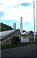
Telecoms pole and old mill chimney, Thrupp
Viewed across the A419 London Road. The chimney is in the Stafford Mill site.
Image: © Jaggery
Taken: 6 Sep 2015
0.15 miles
5
Thrupp bus stop and shelter
Alongside Ferrabee Court flats http://www.geograph.org.uk/photo/4654699 on the west side of the A419 London Road.
Image: © Jaggery
Taken: 6 Sep 2015
0.15 miles
6
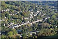
Thrupp in the Golden Valley
Thrupp in the Golden Valley viewed from Rodborough Common.
Image: © Philip Halling
Taken: 11 Oct 2014
0.15 miles
7
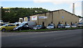
Autocrafts, Thrupp
Autocrafts Services Limited (car sales and MOT test centre) in Stafford Mill, London Road, Thrupp, SE of Stroud.
Image: © Jaggery
Taken: 6 Sep 2015
0.15 miles
8
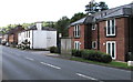
Ferrabee Court, Thrupp
Flats alongside the A419 London Road in Thrupp, Gloucestershire.
Image: © Jaggery
Taken: 6 Sep 2015
0.15 miles
9
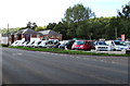
Karz 'n' Trux, Thrupp
Used car business alongside the A419 London Road.
Image: © Jaggery
Taken: 6 Sep 2015
0.16 miles
10
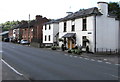
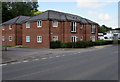
The Old Malakoff, Thrupp
White painted flats viewed across the A419 London Road.
I wondered what the Malakoff was when it was new...
Image: © Jaggery
Taken: 6 Sep 2015
0.16 miles