Boundary Marker, Thrupp Lane, Thrupp
Introduction
The photograph on this page of Boundary Marker, Thrupp Lane, Thrupp by Mr Red as part of the Geograph project.
The Geograph project started in 2005 with the aim of publishing, organising and preserving representative images for every square kilometre of Great Britain, Ireland and the Isle of Man.

There are currently over 7.5m images from over 14,400 individuals and you can help contribute to the project by visiting https://www.geograph.org.uk
Boundary Marker, Thrupp Lane, Thrupp
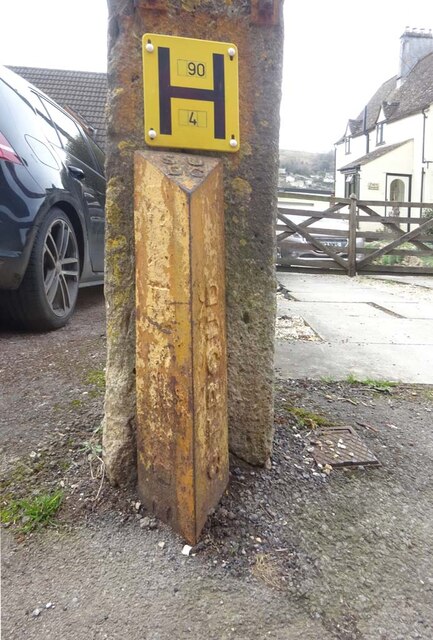
Image: © Mr Red Taken: 22 Mar 2023
At the left-hand gatepost of Nᴼ. 98. Dating from between 1914 and 1974, probably 1936 when other boundaries were moved in the area. It would have signified the limit of Stroud Urban District Council, from Stroud Rural. The Southern face has been ground off to some extent, but can be seen to read "Cainscross" from what is left. This would have been mostly removed because Cainscrioss is (& was) a parish on the Western side of Stroud. This is at the SE. Thrupp was spelled Thrup in the mid 19ᵗʰ C. Note from a Geograph surfer "These markers and signposts were made in a small factory in the car park behind the old Police Station in Stonehouse, below the railway embankment on the Gloucester side of Burdett Road Station. Is it possible that this is a re-use of an old Cainscross signpost. Parts of signs lay around the building before it was demolished." (in the 50s). Inscription: S. U / D. C // (Cainsc?os?) // Stroud Milestone Society National ID: GL_BRITHR01pb
Images are licensed for reuse under creativecommons.org/licenses/by-sa/2.0
Image Location
Latitude
51.731975
Longitude
-2.201193