IMAGES TAKEN NEAR TO
Devon Avenue, CHELTENHAM, GL51 8BX
Introduction
This page details the photographs taken nearby to Devon Avenue, GL51 8BX by members of the Geograph project.
The Geograph project started in 2005 with the aim of publishing, organising and preserving representative images for every square kilometre of Great Britain, Ireland and the Isle of Man.

There are currently over 7.5m images from over14,400 individuals and you can help contribute to the project by visiting https://www.geograph.org.uk
Image Map (Loading...)


Getting Data...Please wait
Leaflet Map data © OpenStreetMap
Images are licensed for reuse under creativecommons.org/licenses/by-sa/2.0
Notes
- Clicking on the map will re-center to the selected point.
- The higher the marker number, the further away the image location is from the centre of the postcode.
Image Listing (110 Images Found)
Images are licensed for reuse under creativecommons.org/licenses/by-sa/2.0
Image
Details
Distance
1
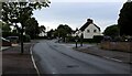
Libertus Road, Cheltenham
Residential road on the western side of Cheltenham
Image: © Chris Heaton
Taken: 31 Jul 2023
0.04 miles
2
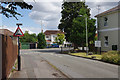
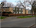
Griffiths Avenue, Cheltenham
Looking towards the junction with Libertus Road in the St Mark's district of Cheltenham. The building on the right is a care home for the elderly - of which there seem to be a large number in this area.
Image: © Stephen McKay
Taken: 25 Jul 2015
0.06 miles
3
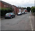
Southwest end of Rowanfield Road, Cheltenham
Towards Libertus Road from near the corner of Roman Road.
Image: © Jaggery
Taken: 3 Aug 2016
0.08 miles
4
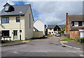
Ashtree Mews, Cheltenham
Cul-de-sac viewed across Rowanfield Road.
Image: © Jaggery
Taken: 3 Aug 2016
0.09 miles
5
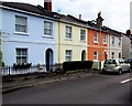
Pastel colours in Roman Road, Cheltenham
Roman Road houses near the corner of Rowanfield Road.
Image: © Jaggery
Taken: 3 Aug 2016
0.10 miles
6
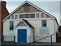
The Parish Hall, Rowanfield Road, Cheltenham
The parish hall Rowanfield Road, Cheltenham. Once used as dining room for St.Marks infants school located in Roman Road but demolished sometime after 2004.
The building was originally opened on 11th December 1911 by the Bishop of Gloucester.
Image: © Colin Manton
Taken: 14 Feb 2004
0.11 miles
7
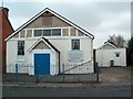
St Marks Parish Hall
St Marks Parish Hall, Rowanfield Road, Cheltenham. This building which stood on the site since 1911, recently disappeared when it was replaced by three dwellings.
Image: © Colin Manton
Taken: 14 Feb 2004
0.11 miles
8
White marked potholes on Rowanfield Road, Cheltenham
Near the corner of Ashtree Mews, white rectangles have been painted around potholes on the surface of Rowanfield Road.
Image: © Jaggery
Taken: 3 Aug 2016
0.12 miles
9
Goldfoot House, Cheltenham
Viewed across Griffiths Avenue. This is the southwest part of a group of interconnected buildings named Goldfoot House, retirement/sheltered housing built in 1976. In 2016, Goldfoot House is managed by Cheltenham Borough Homes.
Image: © Jaggery
Taken: 3 Apr 2016
0.14 miles
10
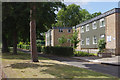
Griffiths Avenue, Cheltenham
Goldfoot house is located on Griffiths Avenue in the leafy St Mark's district of Cheltenham. The building dates from 1976 and comprises 34 sheltered accommodation flats.
Image: © Stephen McKay
Taken: 25 Jul 2015
0.14 miles