IMAGES TAKEN NEAR TO
St. Pauls Walk, CHELTENHAM, GL50 4GA
Introduction
This page details the photographs taken nearby to St. Pauls Walk, GL50 4GA by members of the Geograph project.
The Geograph project started in 2005 with the aim of publishing, organising and preserving representative images for every square kilometre of Great Britain, Ireland and the Isle of Man.

There are currently over 7.5m images from over14,400 individuals and you can help contribute to the project by visiting https://www.geograph.org.uk
Image Map
Images are licensed for reuse under creativecommons.org/licenses/by-sa/2.0
Notes
- Clicking on the map will re-center to the selected point.
- The higher the marker number, the further away the image location is from the centre of the postcode.
Image Listing (54 Images Found)
Images are licensed for reuse under creativecommons.org/licenses/by-sa/2.0
Image
Details
Distance
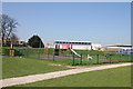
1
Basketball court - Pittville Park
Situated at the far western end of the park.
Image: © Terry Jacombs
Taken: 28 Mar 2012
0.07 miles
2
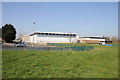
Cheltenham Recreation Centre rear view
Now known as Leisure@Cheltenham, it houses a swimming pool and sports halls.
Image: © Terry Jacombs
Taken: 28 Mar 2012
0.08 miles
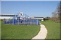
3
Playground in Pittville Park
This is at the far west end of the park. There is a larger playground adjacent to the Evesham Road in the eastern part of the park.
Image: © Terry Jacombs
Taken: 28 Mar 2012
0.08 miles
5
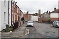
Hanover Street, Cheltenham
Part of the St Paul's district, which I understand is a slightly cheaper but popular residential area. The Hanover Inn as stated on the gable end is no longer a pub. St Paul's Church can be seen over the rooftops.
Image: © Bill Boaden
Taken: 25 May 2018
0.11 miles
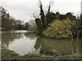
6
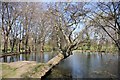
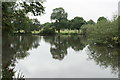
Pittville Lake western end
Pittville has two lakes. The one in the more formal Pittville Park area on the eastern side of the Evesham Road and this one used for boating in the less formal part of the park on the western side of the Evesham Road.
Image: © Terry Jacombs
Taken: 28 Mar 2012
0.12 miles
7
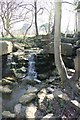
Wyman's Brook leaves Pittville Lake
The two Pittville Lakes were created by damming Wymans Brook. The brook joins the River Swilgate further west on its way to the River Severn.
Image: © Terry Jacombs
Taken: 28 Mar 2012
0.12 miles
8
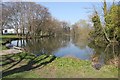
Lake in Pittville Park
Part of a succession of lakes along Wymans Brook.
Image: © Bill Boaden
Taken: 25 May 2018
0.12 miles
9
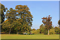
Pittville Park
Pittville Park, in Cheltenham.
Image: © Wayland Smith
Taken: 4 Oct 2015
0.12 miles